You are here: Home > Network List > TA - USArray Transportable Network (new EarthScope stations) Stations List
> Station R11A Troy Canyon, Currant, NV, USA > Earthquake Result Viewer
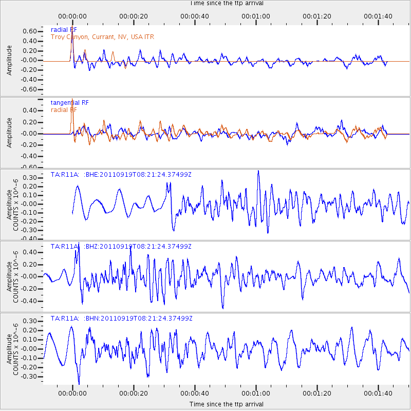
R11A Troy Canyon, Currant, NV, USA - Earthquake Result Viewer
*The percent match for this event was below the threshold and hence no stack was calculated.
| Earthquake location: |
Fox Islands, Aleutian Islands |
| Earthquake latitude/longitude: |
52.0/-172.0 |
| Earthquake time(UTC): |
2011/09/19 (262) 08:14:14 GMT |
| Earthquake Depth: |
31 km |
| Earthquake Magnitude: |
5.5 MB, 5.1 MS, 5.7 MW, 5.6 MW |
| Earthquake Catalog/Contributor: |
WHDF/NEIC |
|
| Network: |
TA USArray Transportable Network (new EarthScope stations) |
| Station: |
R11A Troy Canyon, Currant, NV, USA |
| Lat/Lon: |
38.35 N/115.59 W |
| Elevation: |
1756 m |
|
| Distance: |
41.0 deg |
| Az: |
86.55 deg |
| Baz: |
308.352 deg |
| Ray Param: |
$rayparam |
*The percent match for this event was below the threshold and hence was not used in the summary stack. |
|
| Radial Match: |
66.03747 % |
| Radial Bump: |
377 |
| Transverse Match: |
62.24821 % |
| Transverse Bump: |
349 |
| SOD ConfigId: |
414626 |
| Insert Time: |
2012-01-27 13:40:32.139 +0000 |
| GWidth: |
2.5 |
| Max Bumps: |
400 |
| Tol: |
0.001 |
|
Signal To Noise
| Channel | StoN | STA | LTA |
| TA:R11A: :BHZ:20110919T08:21:24.37499Z | 3.3320363 | 2.4457762E-7 | 7.340186E-8 |
| TA:R11A: :BHN:20110919T08:21:24.37499Z | 2.1793237 | 1.8027224E-7 | 8.271935E-8 |
| TA:R11A: :BHE:20110919T08:21:24.37499Z | 1.7928814 | 1.6370461E-7 | 9.130812E-8 |
| Arrivals |
| Ps | |
| PpPs | |
| PsPs/PpSs | |


