You are here: Home > Network List > TA - USArray Transportable Network (new EarthScope stations) Stations List
> Station D36A Goodland, MN, USA > Earthquake Result Viewer
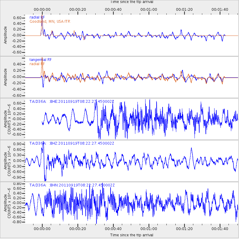
D36A Goodland, MN, USA - Earthquake Result Viewer
*The percent match for this event was below the threshold and hence no stack was calculated.
| Earthquake location: |
Fox Islands, Aleutian Islands |
| Earthquake latitude/longitude: |
52.0/-172.0 |
| Earthquake time(UTC): |
2011/09/19 (262) 08:14:14 GMT |
| Earthquake Depth: |
31 km |
| Earthquake Magnitude: |
5.5 MB, 5.1 MS, 5.7 MW, 5.6 MW |
| Earthquake Catalog/Contributor: |
WHDF/NEIC |
|
| Network: |
TA USArray Transportable Network (new EarthScope stations) |
| Station: |
D36A Goodland, MN, USA |
| Lat/Lon: |
47.18 N/93.16 W |
| Elevation: |
434 m |
|
| Distance: |
49.0 deg |
| Az: |
62.552 deg |
| Baz: |
306.529 deg |
| Ray Param: |
$rayparam |
*The percent match for this event was below the threshold and hence was not used in the summary stack. |
|
| Radial Match: |
57.10414 % |
| Radial Bump: |
337 |
| Transverse Match: |
53.45833 % |
| Transverse Bump: |
361 |
| SOD ConfigId: |
414626 |
| Insert Time: |
2012-01-27 13:53:55.066 +0000 |
| GWidth: |
2.5 |
| Max Bumps: |
400 |
| Tol: |
0.001 |
|
Signal To Noise
| Channel | StoN | STA | LTA |
| TA:D36A: :BHZ:20110919T08:22:27.450002Z | 4.390633 | 5.8330914E-7 | 1.3285309E-7 |
| TA:D36A: :BHN:20110919T08:22:27.450002Z | 1.408727 | 2.9369426E-7 | 2.0848202E-7 |
| TA:D36A: :BHE:20110919T08:22:27.450002Z | 2.3595817 | 4.19788E-7 | 1.7790781E-7 |
| Arrivals |
| Ps | |
| PpPs | |
| PsPs/PpSs | |


