You are here: Home > Network List > CI - Caltech Regional Seismic Network Stations List
> Station LGU Laguna Peak, California, USA > Earthquake Result Viewer
LGU Laguna Peak, California, USA - Earthquake Result Viewer
| Earthquake location: |
Near West Coast Of Colombia |
| Earthquake latitude/longitude: |
4.7/-77.5 |
| Earthquake time(UTC): |
2004/11/15 (320) 09:06:56 GMT |
| Earthquake Depth: |
15 km |
| Earthquake Magnitude: |
6.6 MB, 7.1 MS, 7.2 MW, 7.1 MW |
| Earthquake Catalog/Contributor: |
WHDF/NEIC |
|
| Network: |
CI Caltech Regional Seismic Network |
| Station: |
LGU Laguna Peak, California, USA |
| Lat/Lon: |
34.11 N/119.07 W |
| Elevation: |
381 m |
|
| Distance: |
48.4 deg |
| Az: |
312.584 deg |
| Baz: |
117.816 deg |
| Ray Param: |
0.0693879 |
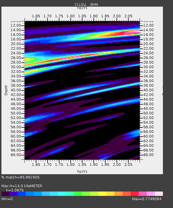
| Estimated Moho Depth: |
14.0 km |
| Estimated Crust Vp/Vs: |
2.10 |
| Assumed Crust Vp: |
6.1 km/s |
| Estimated Crust Vs: |
2.908 km/s |
| Estimated Crust Poisson's Ratio: |
0.35 |
|
| Radial Match: |
95.991905 % |
| Radial Bump: |
337 |
| Transverse Match: |
92.47285 % |
| Transverse Bump: |
400 |
| SOD ConfigId: |
2459 |
| Insert Time: |
2010-02-25 20:18:40.256 +0000 |
| GWidth: |
2.5 |
| Max Bumps: |
400 |
| Tol: |
0.001 |
|

Signal To Noise
| Channel | StoN | STA | LTA |
| CI:LGU: :BHN:20041115T09:15:06.760989Z | 5.2945256 | 2.1876108E-6 | 4.1318356E-7 |
| CI:LGU: :BHE:20041115T09:15:06.760989Z | 9.739697 | 3.1477157E-6 | 3.2318414E-7 |
| CI:LGU: :BHZ:20041115T09:15:06.760989Z | 30.733198 | 7.0248293E-6 | 2.2857463E-7 |
| Arrivals |
| Ps | 2.6 SECOND |
| PpPs | 6.8 SECOND |
| PsPs/PpSs | 9.4 SECOND |


