You are here: Home > Network List > X812 - Deep Structure of Three Continental Sutures in Eastern North America Stations List
> Station QM20 Hay Lake, Maine, USA > Earthquake Result Viewer
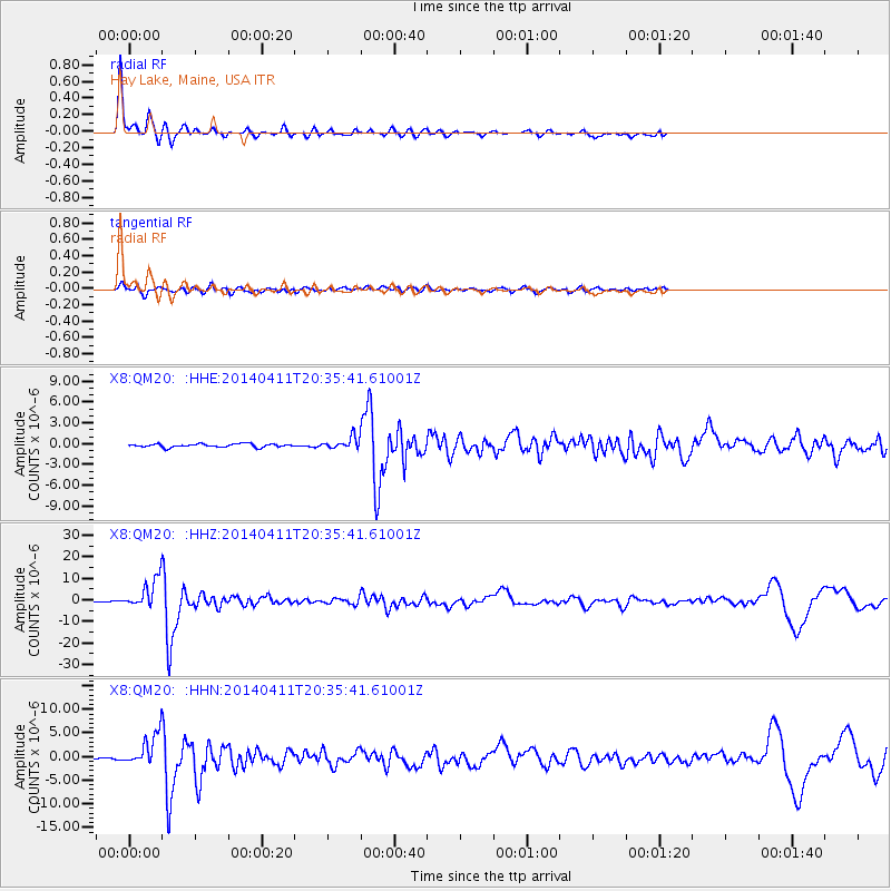
QM20 Hay Lake, Maine, USA - Earthquake Result Viewer
*The percent match for this event was below the threshold and hence no stack was calculated.
| Earthquake location: |
Near Coast Of Nicaragua |
| Earthquake latitude/longitude: |
11.6/-86.0 |
| Earthquake time(UTC): |
2014/04/11 (101) 20:29:13 GMT |
| Earthquake Depth: |
135 km |
| Earthquake Magnitude: |
6.6 MWW, 6.6 MWC, 6.6 MWB, 6.6 MI |
| Earthquake Catalog/Contributor: |
NEIC PDE/NEIC COMCAT |
|
| Network: |
X8 Deep Structure of Three Continental Sutures in Eastern North America |
| Station: |
QM20 Hay Lake, Maine, USA |
| Lat/Lon: |
46.13 N/68.72 W |
| Elevation: |
207 m |
|
| Distance: |
37.4 deg |
| Az: |
19.913 deg |
| Baz: |
208.678 deg |
| Ray Param: |
$rayparam |
*The percent match for this event was below the threshold and hence was not used in the summary stack. |
|
| Radial Match: |
89.51364 % |
| Radial Bump: |
276 |
| Transverse Match: |
72.673706 % |
| Transverse Bump: |
400 |
| SOD ConfigId: |
3390531 |
| Insert Time: |
2019-04-11 07:41:08.232 +0000 |
| GWidth: |
2.5 |
| Max Bumps: |
400 |
| Tol: |
0.001 |
|
Signal To Noise
| Channel | StoN | STA | LTA |
| X8:QM20: :HHZ:20140411T20:35:41.61001Z | 27.87738 | 6.731955E-6 | 2.4148449E-7 |
| X8:QM20: :HHN:20140411T20:35:41.61001Z | 13.831548 | 3.30738E-6 | 2.3911858E-7 |
| X8:QM20: :HHE:20140411T20:35:41.61001Z | 10.14566 | 2.4269168E-6 | 2.392074E-7 |
| Arrivals |
| Ps | |
| PpPs | |
| PsPs/PpSs | |


