You are here: Home > Network List > TA - USArray Transportable Network (new EarthScope stations) Stations List
> Station U39A Green Forest, AR, USA > Earthquake Result Viewer
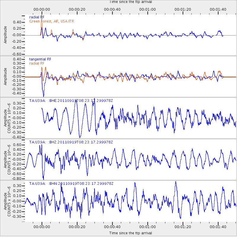
U39A Green Forest, AR, USA - Earthquake Result Viewer
*The percent match for this event was below the threshold and hence no stack was calculated.
| Earthquake location: |
Fox Islands, Aleutian Islands |
| Earthquake latitude/longitude: |
52.0/-172.0 |
| Earthquake time(UTC): |
2011/09/19 (262) 08:14:14 GMT |
| Earthquake Depth: |
31 km |
| Earthquake Magnitude: |
5.5 MB, 5.1 MS, 5.7 MW, 5.6 MW |
| Earthquake Catalog/Contributor: |
WHDF/NEIC |
|
| Network: |
TA USArray Transportable Network (new EarthScope stations) |
| Station: |
U39A Green Forest, AR, USA |
| Lat/Lon: |
36.38 N/93.48 W |
| Elevation: |
433 m |
|
| Distance: |
55.7 deg |
| Az: |
73.229 deg |
| Baz: |
312.868 deg |
| Ray Param: |
$rayparam |
*The percent match for this event was below the threshold and hence was not used in the summary stack. |
|
| Radial Match: |
44.201645 % |
| Radial Bump: |
400 |
| Transverse Match: |
77.931946 % |
| Transverse Bump: |
400 |
| SOD ConfigId: |
414626 |
| Insert Time: |
2012-01-27 14:00:15.514 +0000 |
| GWidth: |
2.5 |
| Max Bumps: |
400 |
| Tol: |
0.001 |
|
Signal To Noise
| Channel | StoN | STA | LTA |
| TA:U39A: :BHZ:20110919T08:23:17.299978Z | 1.978643 | 3.5257992E-7 | 1.7819279E-7 |
| TA:U39A: :BHN:20110919T08:23:17.299978Z | 1.1383071 | 1.0762462E-7 | 9.4547964E-8 |
| TA:U39A: :BHE:20110919T08:23:17.299978Z | 1.1108707 | 2.0593748E-7 | 1.8538385E-7 |
| Arrivals |
| Ps | |
| PpPs | |
| PsPs/PpSs | |


