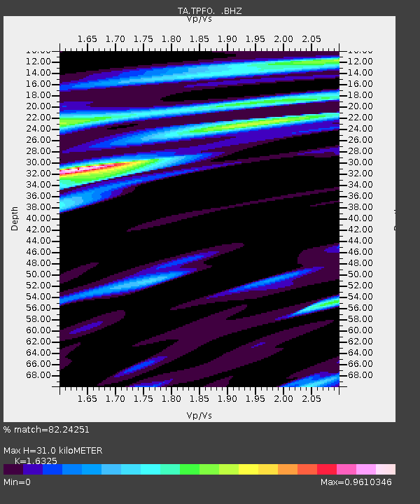
TPFO Pinon Flats, CA, USA - Earthquake Result Viewer
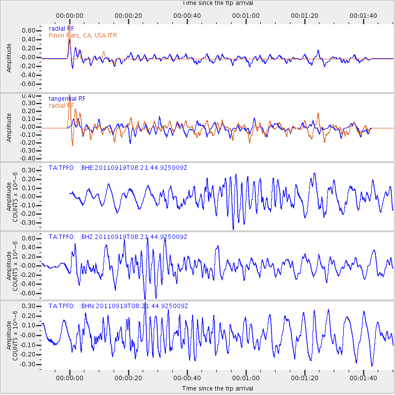
Earthquake location: Fox Islands, Aleutian Islands
Earthquake latitude/longitude: 52.0/-172.0
Earthquake time(UTC): 2011/09/19 (262) 08:14:14 GMT
Earthquake Depth: 31 km
Earthquake Magnitude: 5.5 MB, 5.1 MS, 5.7 MW, 5.6 MW
Earthquake Catalog/Contributor: WHDF/NEIC
Network: TA USArray Transportable Network (new EarthScope stations)
Station: TPFO Pinon Flats, CA, USA
Lat/Lon: 33.61 N/116.45 W
Elevation: 1275 m
Distance: 43.5 deg
Az: 92.594 deg
Baz: 312.319 deg
Ray Param: 0.07243184
Estimated Moho Depth: 31.0 km
Estimated Crust Vp/Vs: 1.63
Assumed Crust Vp: 6.264 km/s
Estimated Crust Vs: 3.837 km/s
Estimated Crust Poisson's Ratio: 0.20
Radial Match: 82.24251 %
Radial Bump: 400
Transverse Match: 61.758705 %
Transverse Bump: 400
SOD ConfigId: 414626
Insert Time: 2012-01-27 14:04:32.268 +0000
GWidth: 2.5
Max Bumps: 400
Tol: 0.001

Signal To Noise

ChannelStoNSTALTA
TA:TPFO: :BHZ:20110919T08:21:44.925009Z3.17674372.2701681E-77.146211E-8
TA:TPFO: :BHN:20110919T08:21:44.925009Z1.23276948.507059E-86.900771E-8
TA:TPFO: :BHE:20110919T08:21:44.925009Z0.98209677.189055E-87.320109E-8
Arrivals
Ps3.4 SECOND
PpPs12 SECOND
PsPs/PpSs16 SECOND