You are here: Home > Network List > TA - USArray Transportable Network (new EarthScope stations) Stations List
> Station P39B Salisbury, MO, USA > Earthquake Result Viewer
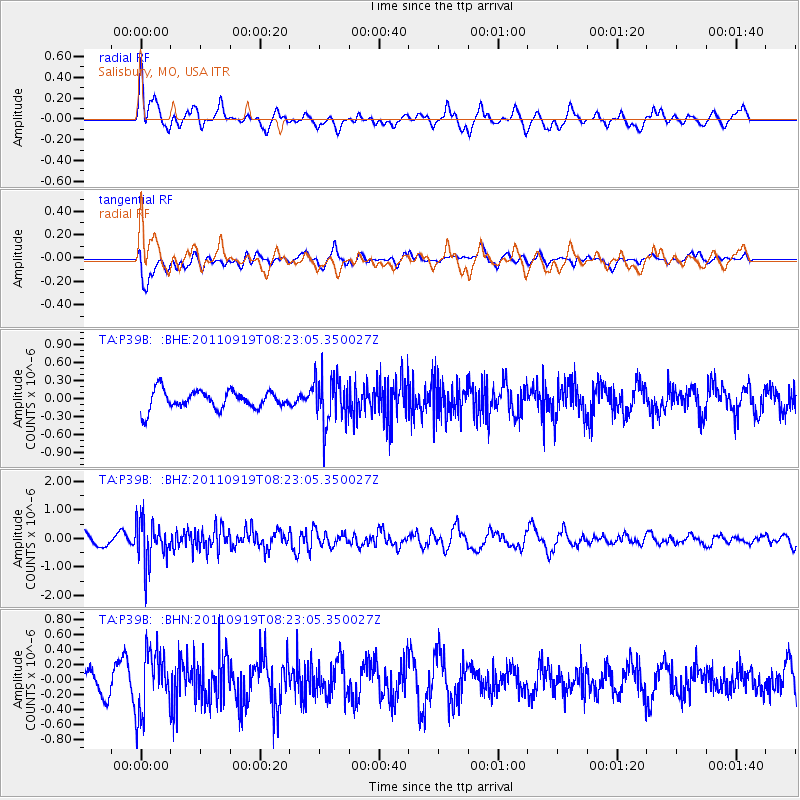
P39B Salisbury, MO, USA - Earthquake Result Viewer
*The percent match for this event was below the threshold and hence no stack was calculated.
| Earthquake location: |
Fox Islands, Aleutian Islands |
| Earthquake latitude/longitude: |
52.0/-172.0 |
| Earthquake time(UTC): |
2011/09/19 (262) 08:14:14 GMT |
| Earthquake Depth: |
31 km |
| Earthquake Magnitude: |
5.5 MB, 5.1 MS, 5.7 MW, 5.6 MW |
| Earthquake Catalog/Contributor: |
WHDF/NEIC |
|
| Network: |
TA USArray Transportable Network (new EarthScope stations) |
| Station: |
P39B Salisbury, MO, USA |
| Lat/Lon: |
39.49 N/92.75 W |
| Elevation: |
226 m |
|
| Distance: |
54.0 deg |
| Az: |
69.946 deg |
| Baz: |
311.423 deg |
| Ray Param: |
$rayparam |
*The percent match for this event was below the threshold and hence was not used in the summary stack. |
|
| Radial Match: |
59.244312 % |
| Radial Bump: |
400 |
| Transverse Match: |
54.158775 % |
| Transverse Bump: |
400 |
| SOD ConfigId: |
414626 |
| Insert Time: |
2012-01-27 14:04:57.462 +0000 |
| GWidth: |
2.5 |
| Max Bumps: |
400 |
| Tol: |
0.001 |
|
Signal To Noise
| Channel | StoN | STA | LTA |
| TA:P39B: :BHZ:20110919T08:23:05.350027Z | 4.095164 | 7.4986593E-7 | 1.8311012E-7 |
| TA:P39B: :BHN:20110919T08:23:05.350027Z | 2.468795 | 4.1894495E-7 | 1.6969611E-7 |
| TA:P39B: :BHE:20110919T08:23:05.350027Z | 2.62631 | 4.022793E-7 | 1.5317282E-7 |
| Arrivals |
| Ps | |
| PpPs | |
| PsPs/PpSs | |


