You are here: Home > Network List > TA - USArray Transportable Network (new EarthScope stations) Stations List
> Station V41A Mountainview, AR, USA > Earthquake Result Viewer
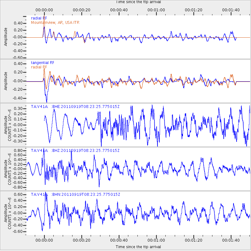
V41A Mountainview, AR, USA - Earthquake Result Viewer
*The percent match for this event was below the threshold and hence no stack was calculated.
| Earthquake location: |
Fox Islands, Aleutian Islands |
| Earthquake latitude/longitude: |
52.0/-172.0 |
| Earthquake time(UTC): |
2011/09/19 (262) 08:14:14 GMT |
| Earthquake Depth: |
31 km |
| Earthquake Magnitude: |
5.5 MB, 5.1 MS, 5.7 MW, 5.6 MW |
| Earthquake Catalog/Contributor: |
WHDF/NEIC |
|
| Network: |
TA USArray Transportable Network (new EarthScope stations) |
| Station: |
V41A Mountainview, AR, USA |
| Lat/Lon: |
35.79 N/92.16 W |
| Elevation: |
413 m |
|
| Distance: |
56.9 deg |
| Az: |
72.869 deg |
| Baz: |
313.446 deg |
| Ray Param: |
$rayparam |
*The percent match for this event was below the threshold and hence was not used in the summary stack. |
|
| Radial Match: |
57.661667 % |
| Radial Bump: |
400 |
| Transverse Match: |
77.3006 % |
| Transverse Bump: |
388 |
| SOD ConfigId: |
414626 |
| Insert Time: |
2012-01-27 14:05:12.394 +0000 |
| GWidth: |
2.5 |
| Max Bumps: |
400 |
| Tol: |
0.001 |
|
Signal To Noise
| Channel | StoN | STA | LTA |
| TA:V41A: :BHZ:20110919T08:23:25.775015Z | 1.4427961 | 3.603842E-7 | 2.497818E-7 |
| TA:V41A: :BHN:20110919T08:23:25.775015Z | 2.3589547 | 3.397503E-7 | 1.4402579E-7 |
| TA:V41A: :BHE:20110919T08:23:25.775015Z | 1.084103 | 1.5024085E-7 | 1.3858539E-7 |
| Arrivals |
| Ps | |
| PpPs | |
| PsPs/PpSs | |


