You are here: Home > Network List > TA - USArray Transportable Network (new EarthScope stations) Stations List
> Station R42A Luebbering, MO, USA > Earthquake Result Viewer
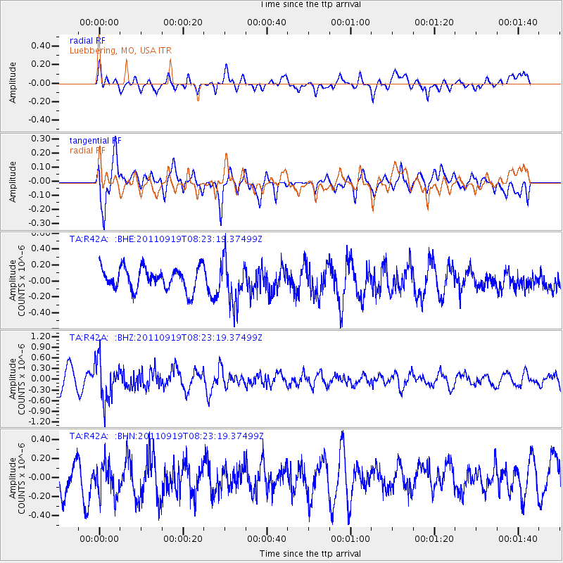
R42A Luebbering, MO, USA - Earthquake Result Viewer
*The percent match for this event was below the threshold and hence no stack was calculated.
| Earthquake location: |
Fox Islands, Aleutian Islands |
| Earthquake latitude/longitude: |
52.0/-172.0 |
| Earthquake time(UTC): |
2011/09/19 (262) 08:14:14 GMT |
| Earthquake Depth: |
31 km |
| Earthquake Magnitude: |
5.5 MB, 5.1 MS, 5.7 MW, 5.6 MW |
| Earthquake Catalog/Contributor: |
WHDF/NEIC |
|
| Network: |
TA USArray Transportable Network (new EarthScope stations) |
| Station: |
R42A Luebbering, MO, USA |
| Lat/Lon: |
38.28 N/90.79 W |
| Elevation: |
218 m |
|
| Distance: |
56.0 deg |
| Az: |
69.791 deg |
| Baz: |
312.559 deg |
| Ray Param: |
$rayparam |
*The percent match for this event was below the threshold and hence was not used in the summary stack. |
|
| Radial Match: |
59.464878 % |
| Radial Bump: |
400 |
| Transverse Match: |
73.18147 % |
| Transverse Bump: |
400 |
| SOD ConfigId: |
414626 |
| Insert Time: |
2012-01-27 14:08:13.839 +0000 |
| GWidth: |
2.5 |
| Max Bumps: |
400 |
| Tol: |
0.001 |
|
Signal To Noise
| Channel | StoN | STA | LTA |
| TA:R42A: :BHZ:20110919T08:23:19.37499Z | 2.0913184 | 5.618813E-7 | 2.6867326E-7 |
| TA:R42A: :BHN:20110919T08:23:19.37499Z | 1.2451606 | 1.9591005E-7 | 1.5733717E-7 |
| TA:R42A: :BHE:20110919T08:23:19.37499Z | 1.9980315 | 2.748912E-7 | 1.3758101E-7 |
| Arrivals |
| Ps | |
| PpPs | |
| PsPs/PpSs | |


