You are here: Home > Network List > AZ - ANZA Regional Network Stations List
> Station SMER AZ.SMER > Earthquake Result Viewer
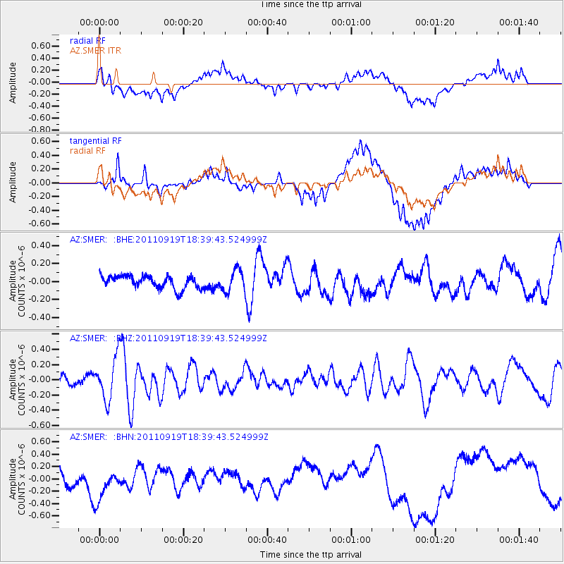
SMER AZ.SMER - Earthquake Result Viewer
*The percent match for this event was below the threshold and hence no stack was calculated.
| Earthquake location: |
Guatemala |
| Earthquake latitude/longitude: |
14.2/-90.2 |
| Earthquake time(UTC): |
2011/09/19 (262) 18:33:55 GMT |
| Earthquake Depth: |
9.0 km |
| Earthquake Magnitude: |
5.6 MW, 5.3 MS, 5.1 MB, 5.6 MW |
| Earthquake Catalog/Contributor: |
WHDF/NEIC |
|
| Network: |
AZ ANZA Regional Network |
| Station: |
SMER AZ.SMER |
| Lat/Lon: |
33.46 N/117.17 W |
| Elevation: |
355 m |
|
| Distance: |
31.1 deg |
| Az: |
312.806 deg |
| Baz: |
121.661 deg |
| Ray Param: |
$rayparam |
*The percent match for this event was below the threshold and hence was not used in the summary stack. |
|
| Radial Match: |
52.890114 % |
| Radial Bump: |
400 |
| Transverse Match: |
59.456596 % |
| Transverse Bump: |
400 |
| SOD ConfigId: |
414626 |
| Insert Time: |
2012-01-27 14:17:52.660 +0000 |
| GWidth: |
2.5 |
| Max Bumps: |
400 |
| Tol: |
0.001 |
|
Signal To Noise
| Channel | StoN | STA | LTA |
| AZ:SMER: :BHZ:20110919T18:39:43.524999Z | 3.887083 | 2.9081536E-7 | 7.481584E-8 |
| AZ:SMER: :BHN:20110919T18:39:43.524999Z | 1.6556922 | 2.637603E-7 | 1.5930516E-7 |
| AZ:SMER: :BHE:20110919T18:39:43.524999Z | 1.7691517 | 1.254305E-7 | 7.089867E-8 |
| Arrivals |
| Ps | |
| PpPs | |
| PsPs/PpSs | |


