You are here: Home > Network List > CI - Caltech Regional Seismic Network Stations List
> Station IRM Iron Mountain Pumping Station, Eagle Mtn., CA, USA > Earthquake Result Viewer
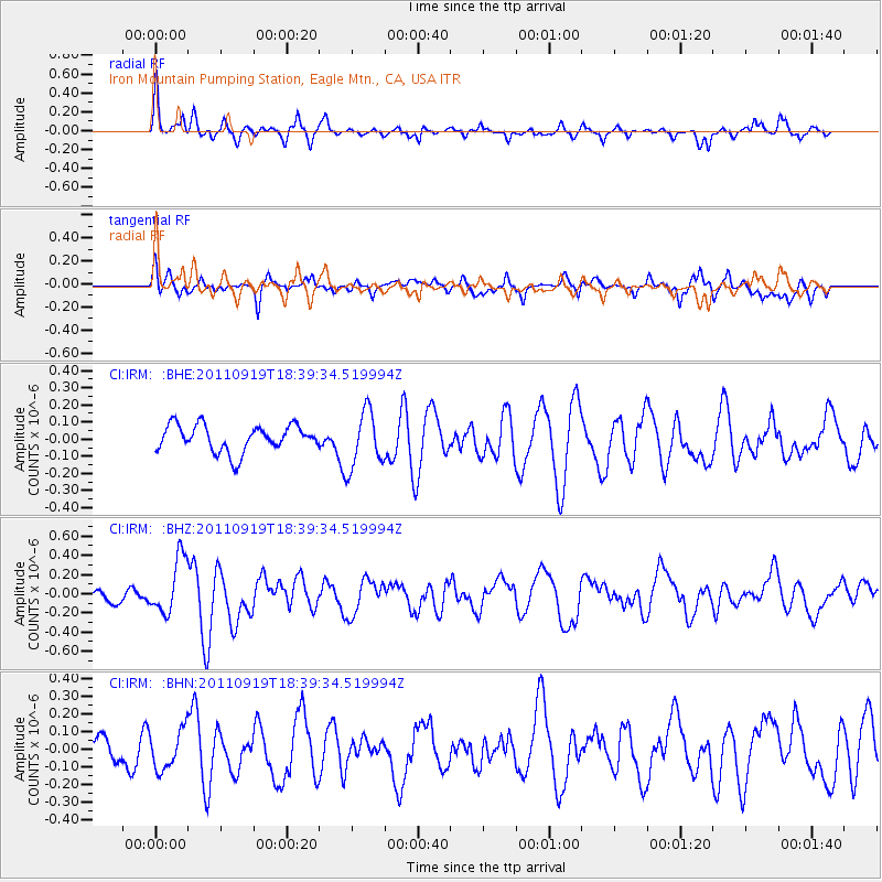
IRM Iron Mountain Pumping Station, Eagle Mtn., CA, USA - Earthquake Result Viewer
*The percent match for this event was below the threshold and hence no stack was calculated.
| Earthquake location: |
Guatemala |
| Earthquake latitude/longitude: |
14.2/-90.2 |
| Earthquake time(UTC): |
2011/09/19 (262) 18:33:55 GMT |
| Earthquake Depth: |
9.0 km |
| Earthquake Magnitude: |
5.6 MW, 5.3 MS, 5.1 MB, 5.6 MW |
| Earthquake Catalog/Contributor: |
WHDF/NEIC |
|
| Network: |
CI Caltech Regional Seismic Network |
| Station: |
IRM Iron Mountain Pumping Station, Eagle Mtn., CA, USA |
| Lat/Lon: |
34.16 N/115.15 W |
| Elevation: |
567 m |
|
| Distance: |
30.1 deg |
| Az: |
315.782 deg |
| Baz: |
125.346 deg |
| Ray Param: |
$rayparam |
*The percent match for this event was below the threshold and hence was not used in the summary stack. |
|
| Radial Match: |
69.15642 % |
| Radial Bump: |
348 |
| Transverse Match: |
58.270416 % |
| Transverse Bump: |
400 |
| SOD ConfigId: |
414626 |
| Insert Time: |
2012-01-27 14:19:17.627 +0000 |
| GWidth: |
2.5 |
| Max Bumps: |
400 |
| Tol: |
0.001 |
|
Signal To Noise
| Channel | StoN | STA | LTA |
| CI:IRM: :BHZ:20110919T18:39:34.519994Z | 3.307411 | 2.9313824E-7 | 8.863073E-8 |
| CI:IRM: :BHN:20110919T18:39:34.519994Z | 1.2791195 | 1.1113015E-7 | 8.688019E-8 |
| CI:IRM: :BHE:20110919T18:39:34.519994Z | 2.13713 | 1.6445061E-7 | 7.694928E-8 |
| Arrivals |
| Ps | |
| PpPs | |
| PsPs/PpSs | |


