You are here: Home > Network List > TA - USArray Transportable Network (new EarthScope stations) Stations List
> Station C33A Trail, MN, USA > Earthquake Result Viewer
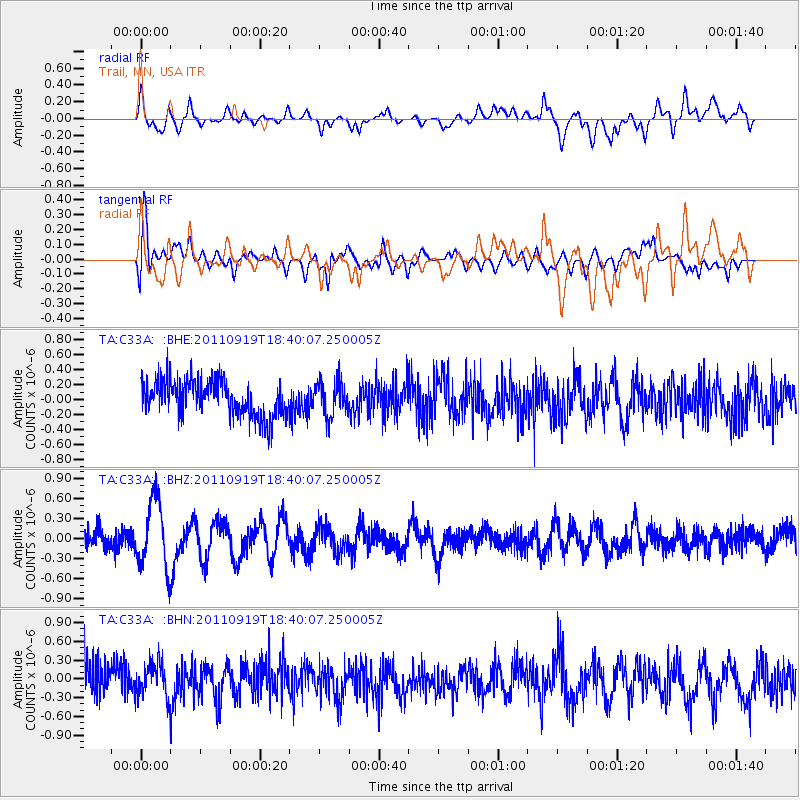
C33A Trail, MN, USA - Earthquake Result Viewer
*The percent match for this event was below the threshold and hence no stack was calculated.
| Earthquake location: |
Guatemala |
| Earthquake latitude/longitude: |
14.2/-90.2 |
| Earthquake time(UTC): |
2011/09/19 (262) 18:33:55 GMT |
| Earthquake Depth: |
9.0 km |
| Earthquake Magnitude: |
5.6 MW, 5.3 MS, 5.1 MB, 5.6 MW |
| Earthquake Catalog/Contributor: |
WHDF/NEIC |
|
| Network: |
TA USArray Transportable Network (new EarthScope stations) |
| Station: |
C33A Trail, MN, USA |
| Lat/Lon: |
47.76 N/95.77 W |
| Elevation: |
388 m |
|
| Distance: |
33.8 deg |
| Az: |
353.28 deg |
| Baz: |
170.317 deg |
| Ray Param: |
$rayparam |
*The percent match for this event was below the threshold and hence was not used in the summary stack. |
|
| Radial Match: |
55.050625 % |
| Radial Bump: |
400 |
| Transverse Match: |
55.654922 % |
| Transverse Bump: |
400 |
| SOD ConfigId: |
414626 |
| Insert Time: |
2012-01-27 14:24:05.311 +0000 |
| GWidth: |
2.5 |
| Max Bumps: |
400 |
| Tol: |
0.001 |
|
Signal To Noise
| Channel | StoN | STA | LTA |
| TA:C33A: :BHZ:20110919T18:40:07.250005Z | 3.1698565 | 5.07942E-7 | 1.6024131E-7 |
| TA:C33A: :BHN:20110919T18:40:07.250005Z | 0.9712326 | 2.802889E-7 | 2.885909E-7 |
| TA:C33A: :BHE:20110919T18:40:07.250005Z | 0.9669137 | 2.2965246E-7 | 2.3751082E-7 |
| Arrivals |
| Ps | |
| PpPs | |
| PsPs/PpSs | |


