You are here: Home > Network List > TA - USArray Transportable Network (new EarthScope stations) Stations List
> Station E34A Wadena, MN, USA > Earthquake Result Viewer
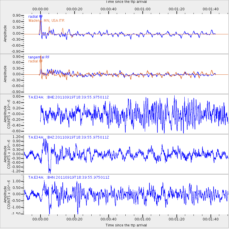
E34A Wadena, MN, USA - Earthquake Result Viewer
*The percent match for this event was below the threshold and hence no stack was calculated.
| Earthquake location: |
Guatemala |
| Earthquake latitude/longitude: |
14.2/-90.2 |
| Earthquake time(UTC): |
2011/09/19 (262) 18:33:55 GMT |
| Earthquake Depth: |
9.0 km |
| Earthquake Magnitude: |
5.6 MW, 5.3 MS, 5.1 MB, 5.6 MW |
| Earthquake Catalog/Contributor: |
WHDF/NEIC |
|
| Network: |
TA USArray Transportable Network (new EarthScope stations) |
| Station: |
E34A Wadena, MN, USA |
| Lat/Lon: |
46.51 N/95.17 W |
| Elevation: |
430 m |
|
| Distance: |
32.5 deg |
| Az: |
353.655 deg |
| Baz: |
171.072 deg |
| Ray Param: |
$rayparam |
*The percent match for this event was below the threshold and hence was not used in the summary stack. |
|
| Radial Match: |
71.29583 % |
| Radial Bump: |
400 |
| Transverse Match: |
59.1021 % |
| Transverse Bump: |
400 |
| SOD ConfigId: |
414626 |
| Insert Time: |
2012-01-27 14:24:11.127 +0000 |
| GWidth: |
2.5 |
| Max Bumps: |
400 |
| Tol: |
0.001 |
|
Signal To Noise
| Channel | StoN | STA | LTA |
| TA:E34A: :BHZ:20110919T18:39:55.975011Z | 3.8945262 | 5.6016086E-7 | 1.4383286E-7 |
| TA:E34A: :BHN:20110919T18:39:55.975011Z | 2.4780533 | 3.9534504E-7 | 1.5953856E-7 |
| TA:E34A: :BHE:20110919T18:39:55.975011Z | 0.9253367 | 1.3815497E-7 | 1.493024E-7 |
| Arrivals |
| Ps | |
| PpPs | |
| PsPs/PpSs | |


