You are here: Home > Network List > TA - USArray Transportable Network (new EarthScope stations) Stations List
> Station G43A Wallace, MI, USA > Earthquake Result Viewer
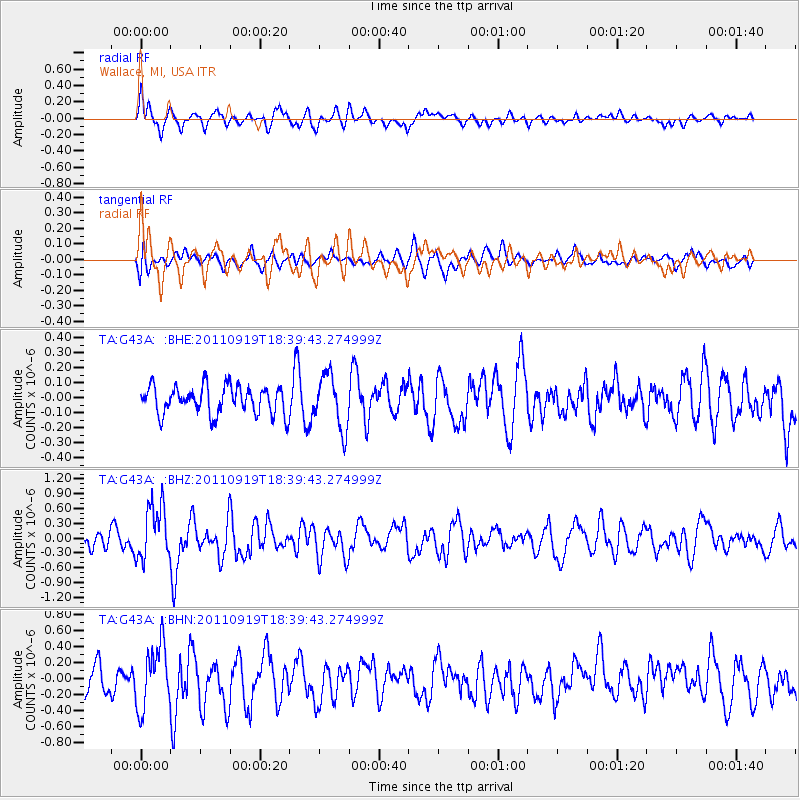
G43A Wallace, MI, USA - Earthquake Result Viewer
*The percent match for this event was below the threshold and hence no stack was calculated.
| Earthquake location: |
Guatemala |
| Earthquake latitude/longitude: |
14.2/-90.2 |
| Earthquake time(UTC): |
2011/09/19 (262) 18:33:55 GMT |
| Earthquake Depth: |
9.0 km |
| Earthquake Magnitude: |
5.6 MW, 5.3 MS, 5.1 MB, 5.6 MW |
| Earthquake Catalog/Contributor: |
WHDF/NEIC |
|
| Network: |
TA USArray Transportable Network (new EarthScope stations) |
| Station: |
G43A Wallace, MI, USA |
| Lat/Lon: |
45.26 N/87.69 W |
| Elevation: |
213 m |
|
| Distance: |
31.0 deg |
| Az: |
3.496 deg |
| Baz: |
184.803 deg |
| Ray Param: |
$rayparam |
*The percent match for this event was below the threshold and hence was not used in the summary stack. |
|
| Radial Match: |
66.250984 % |
| Radial Bump: |
400 |
| Transverse Match: |
46.59829 % |
| Transverse Bump: |
400 |
| SOD ConfigId: |
414626 |
| Insert Time: |
2012-01-27 14:27:27.618 +0000 |
| GWidth: |
2.5 |
| Max Bumps: |
400 |
| Tol: |
0.001 |
|
Signal To Noise
| Channel | StoN | STA | LTA |
| TA:G43A: :BHZ:20110919T18:39:43.274999Z | 3.238318 | 5.5864086E-7 | 1.7250959E-7 |
| TA:G43A: :BHN:20110919T18:39:43.274999Z | 1.9246666 | 3.9278325E-7 | 2.0407859E-7 |
| TA:G43A: :BHE:20110919T18:39:43.274999Z | 1.9221915 | 1.7824318E-7 | 9.272915E-8 |
| Arrivals |
| Ps | |
| PpPs | |
| PsPs/PpSs | |


