You are here: Home > Network List > CI - Caltech Regional Seismic Network Stations List
> Station CIA CIA, Avalon Catalina Island, CA, USA > Earthquake Result Viewer
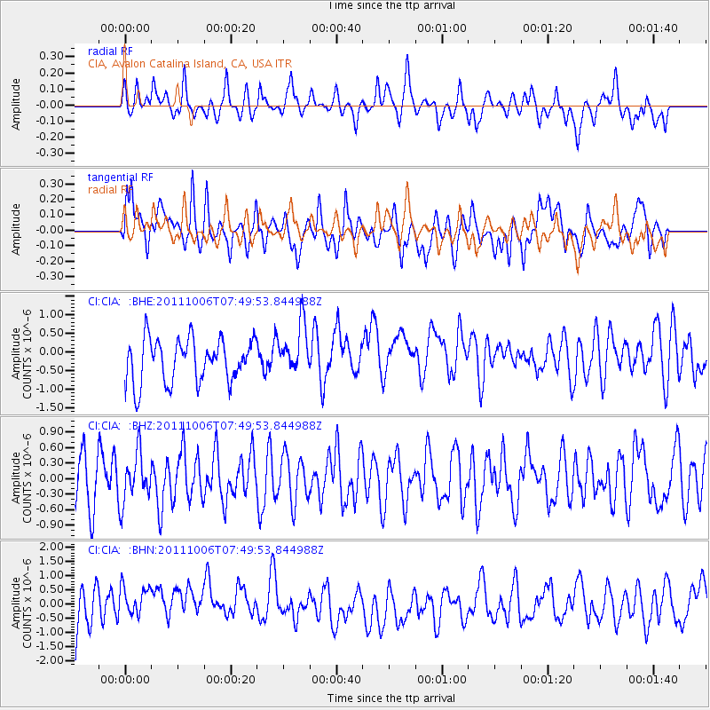
CIA CIA, Avalon Catalina Island, CA, USA - Earthquake Result Viewer
*The percent match for this event was below the threshold and hence no stack was calculated.
| Earthquake location: |
W. Caroline Islands, Micronesia |
| Earthquake latitude/longitude: |
9.7/138.2 |
| Earthquake time(UTC): |
2011/10/06 (279) 07:37:01 GMT |
| Earthquake Depth: |
20 km |
| Earthquake Magnitude: |
5.6 MB, 5.5 MS, 5.9 MW, 5.8 MW |
| Earthquake Catalog/Contributor: |
WHDF/NEIC |
|
| Network: |
CI Caltech Regional Seismic Network |
| Station: |
CIA CIA, Avalon Catalina Island, CA, USA |
| Lat/Lon: |
33.40 N/118.41 W |
| Elevation: |
467 m |
|
| Distance: |
95.7 deg |
| Az: |
54.878 deg |
| Baz: |
285.425 deg |
| Ray Param: |
$rayparam |
*The percent match for this event was below the threshold and hence was not used in the summary stack. |
|
| Radial Match: |
48.248333 % |
| Radial Bump: |
400 |
| Transverse Match: |
52.130222 % |
| Transverse Bump: |
400 |
| SOD ConfigId: |
424168 |
| Insert Time: |
2012-02-04 04:54:26.240 +0000 |
| GWidth: |
2.5 |
| Max Bumps: |
400 |
| Tol: |
0.001 |
|
Signal To Noise
| Channel | StoN | STA | LTA |
| CI:CIA: :BHZ:20111006T07:49:53.844988Z | 0.82279736 | 4.6628568E-7 | 5.667078E-7 |
| CI:CIA: :BHN:20111006T07:49:53.844988Z | 1.1118402 | 7.078225E-7 | 6.366225E-7 |
| CI:CIA: :BHE:20111006T07:49:53.844988Z | 1.1542258 | 6.753781E-7 | 5.8513507E-7 |
| Arrivals |
| Ps | |
| PpPs | |
| PsPs/PpSs | |


