You are here: Home > Network List > CI - Caltech Regional Seismic Network Stations List
> Station SMM Simmler, CA, USA > Earthquake Result Viewer
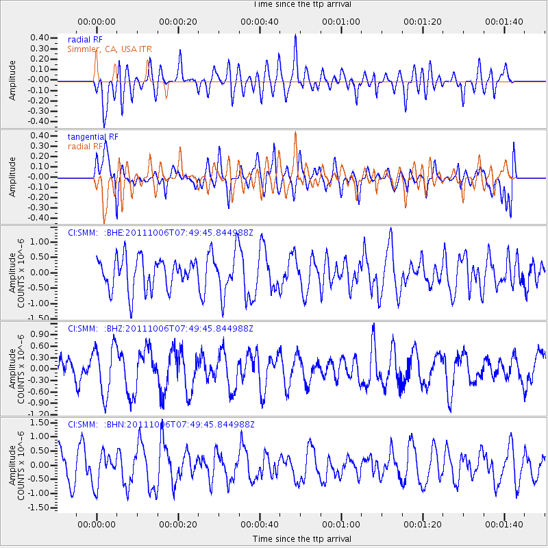
SMM Simmler, CA, USA - Earthquake Result Viewer
*The percent match for this event was below the threshold and hence no stack was calculated.
| Earthquake location: |
W. Caroline Islands, Micronesia |
| Earthquake latitude/longitude: |
9.7/138.2 |
| Earthquake time(UTC): |
2011/10/06 (279) 07:37:01 GMT |
| Earthquake Depth: |
20 km |
| Earthquake Magnitude: |
5.6 MB, 5.5 MS, 5.9 MW, 5.8 MW |
| Earthquake Catalog/Contributor: |
WHDF/NEIC |
|
| Network: |
CI Caltech Regional Seismic Network |
| Station: |
SMM Simmler, CA, USA |
| Lat/Lon: |
35.31 N/120.00 W |
| Elevation: |
599 m |
|
| Distance: |
93.9 deg |
| Az: |
53.371 deg |
| Baz: |
284.662 deg |
| Ray Param: |
$rayparam |
*The percent match for this event was below the threshold and hence was not used in the summary stack. |
|
| Radial Match: |
41.448853 % |
| Radial Bump: |
400 |
| Transverse Match: |
49.56224 % |
| Transverse Bump: |
400 |
| SOD ConfigId: |
424168 |
| Insert Time: |
2012-02-04 04:54:48.693 +0000 |
| GWidth: |
2.5 |
| Max Bumps: |
400 |
| Tol: |
0.001 |
|
Signal To Noise
| Channel | StoN | STA | LTA |
| CI:SMM: :BHZ:20111006T07:49:45.844988Z | 3.0602872 | 6.547875E-7 | 2.1396276E-7 |
| CI:SMM: :BHN:20111006T07:49:45.844988Z | 1.0290307 | 5.565607E-7 | 5.4085916E-7 |
| CI:SMM: :BHE:20111006T07:49:45.844988Z | 1.4013741 | 7.064169E-7 | 5.0408875E-7 |
| Arrivals |
| Ps | |
| PpPs | |
| PsPs/PpSs | |


