You are here: Home > Network List > TA - USArray Transportable Network (new EarthScope stations) Stations List
> Station O03D Paynes Creek, CA, USA > Earthquake Result Viewer
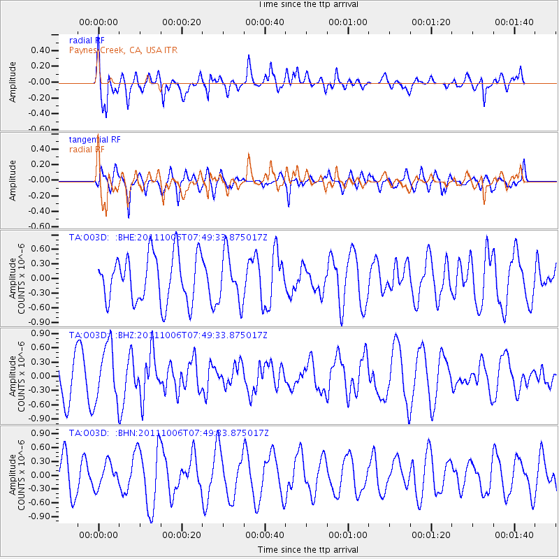
O03D Paynes Creek, CA, USA - Earthquake Result Viewer
*The percent match for this event was below the threshold and hence no stack was calculated.
| Earthquake location: |
W. Caroline Islands, Micronesia |
| Earthquake latitude/longitude: |
9.7/138.2 |
| Earthquake time(UTC): |
2011/10/06 (279) 07:37:01 GMT |
| Earthquake Depth: |
20 km |
| Earthquake Magnitude: |
5.6 MB, 5.5 MS, 5.9 MW, 5.8 MW |
| Earthquake Catalog/Contributor: |
WHDF/NEIC |
|
| Network: |
TA USArray Transportable Network (new EarthScope stations) |
| Station: |
O03D Paynes Creek, CA, USA |
| Lat/Lon: |
40.29 N/121.80 W |
| Elevation: |
968 m |
|
| Distance: |
91.3 deg |
| Az: |
48.898 deg |
| Baz: |
283.761 deg |
| Ray Param: |
$rayparam |
*The percent match for this event was below the threshold and hence was not used in the summary stack. |
|
| Radial Match: |
72.17211 % |
| Radial Bump: |
400 |
| Transverse Match: |
59.206306 % |
| Transverse Bump: |
400 |
| SOD ConfigId: |
424168 |
| Insert Time: |
2012-02-04 05:00:29.854 +0000 |
| GWidth: |
2.5 |
| Max Bumps: |
400 |
| Tol: |
0.001 |
|
Signal To Noise
| Channel | StoN | STA | LTA |
| TA:O03D: :BHZ:20111006T07:49:33.875017Z | 1.5461986 | 5.826796E-7 | 3.7684654E-7 |
| TA:O03D: :BHN:20111006T07:49:33.875017Z | 0.92696285 | 2.632434E-7 | 2.8398486E-7 |
| TA:O03D: :BHE:20111006T07:49:33.875017Z | 1.0238589 | 5.0151976E-7 | 4.8983287E-7 |
| Arrivals |
| Ps | |
| PpPs | |
| PsPs/PpSs | |


