You are here: Home > Network List > TA - USArray Transportable Network (new EarthScope stations) Stations List
> Station J01D Myrtle Point, OR, USA > Earthquake Result Viewer
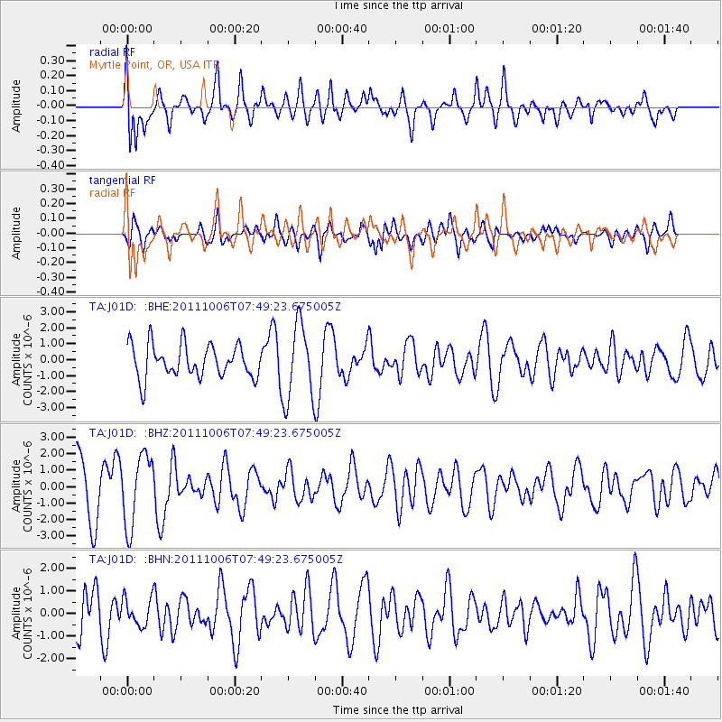
J01D Myrtle Point, OR, USA - Earthquake Result Viewer
*The percent match for this event was below the threshold and hence no stack was calculated.
| Earthquake location: |
W. Caroline Islands, Micronesia |
| Earthquake latitude/longitude: |
9.7/138.2 |
| Earthquake time(UTC): |
2011/10/06 (279) 07:37:01 GMT |
| Earthquake Depth: |
20 km |
| Earthquake Magnitude: |
5.6 MB, 5.5 MS, 5.9 MW, 5.8 MW |
| Earthquake Catalog/Contributor: |
WHDF/NEIC |
|
| Network: |
TA USArray Transportable Network (new EarthScope stations) |
| Station: |
J01D Myrtle Point, OR, USA |
| Lat/Lon: |
43.16 N/123.93 W |
| Elevation: |
131 m |
|
| Distance: |
89.1 deg |
| Az: |
46.469 deg |
| Baz: |
282.356 deg |
| Ray Param: |
$rayparam |
*The percent match for this event was below the threshold and hence was not used in the summary stack. |
|
| Radial Match: |
71.58704 % |
| Radial Bump: |
400 |
| Transverse Match: |
43.44465 % |
| Transverse Bump: |
400 |
| SOD ConfigId: |
424168 |
| Insert Time: |
2012-02-04 05:00:41.195 +0000 |
| GWidth: |
2.5 |
| Max Bumps: |
400 |
| Tol: |
0.001 |
|
Signal To Noise
| Channel | StoN | STA | LTA |
| TA:J01D: :BHZ:20111006T07:49:23.675005Z | 1.1936035 | 2.1639305E-6 | 1.8129391E-6 |
| TA:J01D: :BHN:20111006T07:49:23.675005Z | 0.6224596 | 6.199239E-7 | 9.959264E-7 |
| TA:J01D: :BHE:20111006T07:49:23.675005Z | 2.3223128 | 2.3862594E-6 | 1.0275357E-6 |
| Arrivals |
| Ps | |
| PpPs | |
| PsPs/PpSs | |


