You are here: Home > Network List > 2G - Testing of the effectiveness of incorporating seismic data in seismic hazard ass Stations List
> Station IUGFS Indiana Univ Geologic Field Station, Cardwell, MT > Earthquake Result Viewer
IUGFS Indiana Univ Geologic Field Station, Cardwell, MT - Earthquake Result Viewer
| Earthquake location: |
Solomon Islands |
| Earthquake latitude/longitude: |
-7.2/155.2 |
| Earthquake time(UTC): |
2014/04/12 (102) 06:15:37 GMT |
| Earthquake Depth: |
41 km |
| Earthquake Magnitude: |
5.4 MW |
| Earthquake Catalog/Contributor: |
ISC/ISC |
|
| Network: |
2G Testing of the effectiveness of incorporating seismic data in seismic hazard ass |
| Station: |
IUGFS Indiana Univ Geologic Field Station, Cardwell, MT |
| Lat/Lon: |
45.73 N/111.97 W |
| Elevation: |
1634 m |
|
| Distance: |
97.0 deg |
| Az: |
44.824 deg |
| Baz: |
266.995 deg |
| Ray Param: |
0.04031022 |
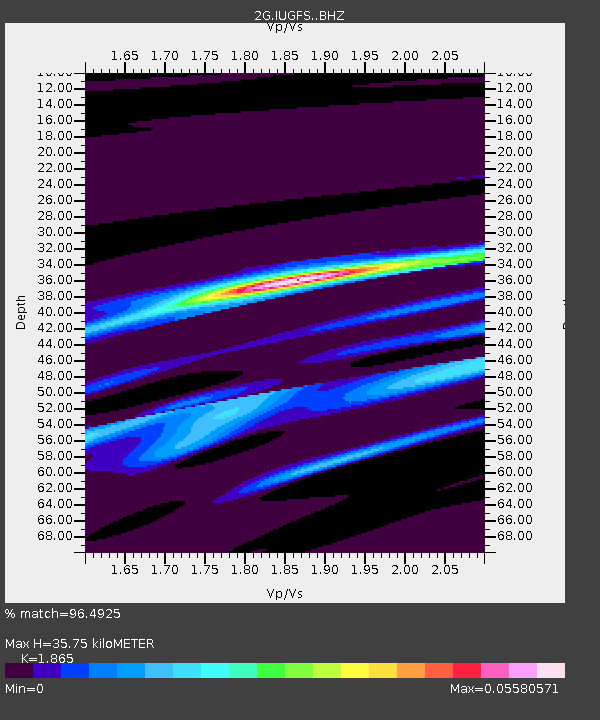
| Estimated Moho Depth: |
35.75 km |
| Estimated Crust Vp/Vs: |
1.87 |
| Assumed Crust Vp: |
6.35 km/s |
| Estimated Crust Vs: |
3.405 km/s |
| Estimated Crust Poisson's Ratio: |
0.30 |
|
| Radial Match: |
96.4925 % |
| Radial Bump: |
304 |
| Transverse Match: |
99.96003 % |
| Transverse Bump: |
3 |
| SOD ConfigId: |
3390531 |
| Insert Time: |
2019-04-11 07:54:47.218 +0000 |
| GWidth: |
2.5 |
| Max Bumps: |
400 |
| Tol: |
0.001 |
|

Signal To Noise
| Channel | StoN | STA | LTA |
| 2G:IUGFS: :BHZ:20140412T06:28:33.200005Z | 1.2190812 | 3.3392692E-7 | 2.739169E-7 |
| 2G:IUGFS: :BHN:20140412T06:28:33.200005Z | 1.2030276 | 3.9653693E-7 | 3.2961583E-7 |
| 2G:IUGFS: :BHE:20140412T06:28:33.200005Z | 0.86997 | 6.601758E-9 | 7.588489E-9 |
| Arrivals |
| Ps | 5.0 SECOND |
| PpPs | 16 SECOND |
| PsPs/PpSs | 21 SECOND |


