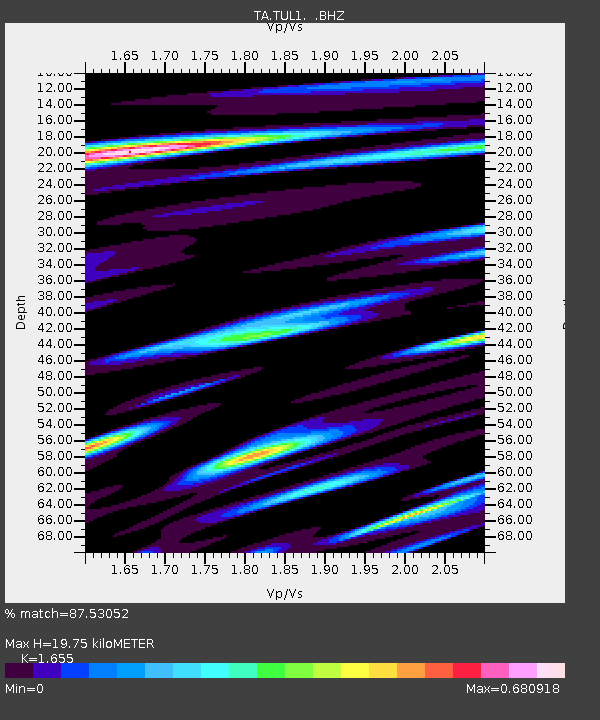
TUL1 Leonard, OK, USA - Earthquake Result Viewer
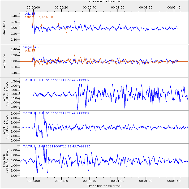
Earthquake location: Salta Province, Argentina
Earthquake latitude/longitude: -24.2/-64.2
Earthquake time(UTC): 2011/10/06 (279) 11:12:30 GMT
Earthquake Depth: 15 km
Earthquake Magnitude: 6.5 MB, 5.7 MS, 6.1 MW, 5.9 MW
Earthquake Catalog/Contributor: WHDF/NEIC
Network: TA USArray Transportable Network (new EarthScope stations)
Station: TUL1 Leonard, OK, USA
Lat/Lon: 35.91 N/95.79 W
Elevation: 256 m
Distance: 66.8 deg
Az: 332.457 deg
Baz: 148.652 deg
Ray Param: 0.057360962
Estimated Moho Depth: 19.75 km
Estimated Crust Vp/Vs: 1.65
Assumed Crust Vp: 6.498 km/s
Estimated Crust Vs: 3.926 km/s
Estimated Crust Poisson's Ratio: 0.21
Radial Match: 87.53052 %
Radial Bump: 400
Transverse Match: 70.68483 %
Transverse Bump: 400
SOD ConfigId: 424168
Insert Time: 2012-02-04 05:30:24.926 +0000
GWidth: 2.5
Max Bumps: 400
Tol: 0.001

Signal To Noise

ChannelStoNSTALTA
TA:TUL1: :BHZ:20111006T11:22:49.749993Z16.3145482.6293724E-61.6116735E-7
TA:TUL1: :BHN:20111006T11:22:49.749993Z4.74342161.1433801E-62.4104546E-7
TA:TUL1: :BHE:20111006T11:22:49.749993Z5.7793258.1158356E-71.4042878E-7
Arrivals
Ps2.1 SECOND
PpPs7.7 SECOND
PsPs/PpSs9.8 SECOND