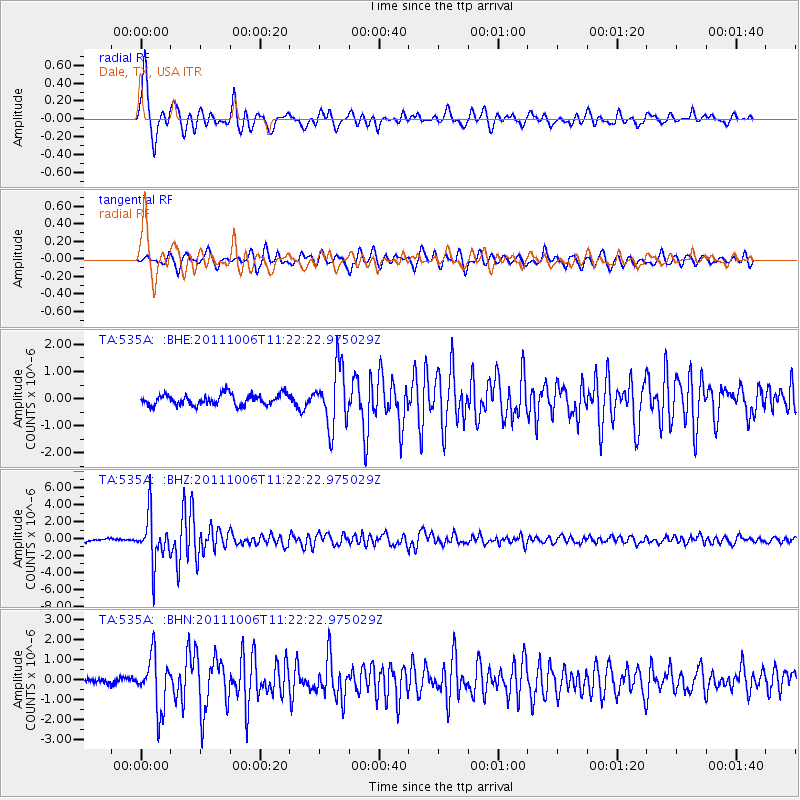
535A Dale, TX, USA - Earthquake Result Viewer
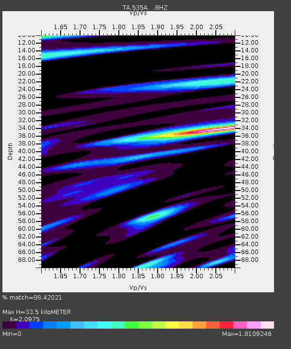
Earthquake location: Salta Province, Argentina
Earthquake latitude/longitude: -24.2/-64.2
Earthquake time(UTC): 2011/10/06 (279) 11:12:30 GMT
Earthquake Depth: 15 km
Earthquake Magnitude: 6.5 MB, 5.7 MS, 6.1 MW, 5.9 MW
Earthquake Catalog/Contributor: WHDF/NEIC
Network: TA USArray Transportable Network (new EarthScope stations)
Station: 535A Dale, TX, USA
Lat/Lon: 30.03 N/97.57 W
Elevation: 170 m
Distance: 62.7 deg
Az: 327.548 deg
Baz: 145.591 deg
Ray Param: 0.060050122
Estimated Moho Depth: 33.5 km
Estimated Crust Vp/Vs: 2.10
Assumed Crust Vp: 6.347 km/s
Estimated Crust Vs: 3.026 km/s
Estimated Crust Poisson's Ratio: 0.35
Radial Match: 88.42021 %
Radial Bump: 386
Transverse Match: 84.30414 %
Transverse Bump: 400
SOD ConfigId: 424168
Insert Time: 2012-02-04 05:32:40.426 +0000
GWidth: 2.5
Max Bumps: 400
Tol: 0.001

Signal To Noise

ChannelStoNSTALTA
TA:535A: :BHZ:20111006T11:22:22.975029Z19.2055022.816501E-61.4665073E-7
TA:535A: :BHN:20111006T11:22:22.975029Z6.42238471.3177407E-62.0517935E-7
TA:535A: :BHE:20111006T11:22:22.975029Z5.4098041.0869803E-62.0092786E-7
Arrivals
Ps6.0 SECOND
PpPs16 SECOND
PsPs/PpSs22 SECOND