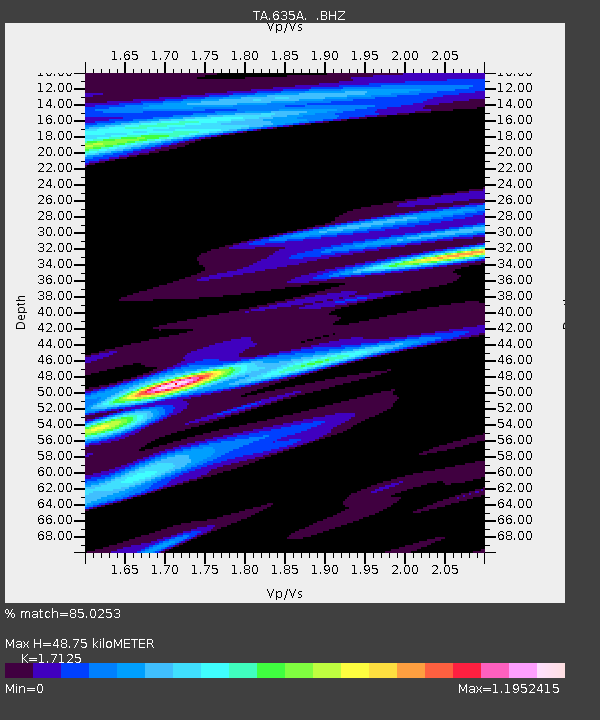
635A Leesville, TX, USA - Earthquake Result Viewer

Earthquake location: Salta Province, Argentina
Earthquake latitude/longitude: -24.2/-64.2
Earthquake time(UTC): 2011/10/06 (279) 11:12:30 GMT
Earthquake Depth: 15 km
Earthquake Magnitude: 6.5 MB, 5.7 MS, 6.1 MW, 5.9 MW
Earthquake Catalog/Contributor: WHDF/NEIC
Network: TA USArray Transportable Network (new EarthScope stations)
Station: 635A Leesville, TX, USA
Lat/Lon: 29.39 N/97.77 W
Elevation: 119 m
Distance: 62.3 deg
Az: 326.975 deg
Baz: 145.226 deg
Ray Param: 0.060329955
Estimated Moho Depth: 48.75 km
Estimated Crust Vp/Vs: 1.71
Assumed Crust Vp: 5.78 km/s
Estimated Crust Vs: 3.375 km/s
Estimated Crust Poisson's Ratio: 0.24
Radial Match: 85.0253 %
Radial Bump: 400
Transverse Match: 70.20449 %
Transverse Bump: 400
SOD ConfigId: 424168
Insert Time: 2012-02-04 05:32:51.067 +0000
GWidth: 2.5
Max Bumps: 400
Tol: 0.001

Signal To Noise

ChannelStoNSTALTA
TA:635A: :BHZ:20111006T11:22:20.124993Z33.875743.1783584E-69.382402E-8
TA:635A: :BHN:20111006T11:22:20.124993Z2.5070481.0379738E-64.140223E-7
TA:635A: :BHE:20111006T11:22:20.124993Z2.99079688.4217584E-72.815891E-7
Arrivals
Ps6.2 SECOND
PpPs22 SECOND
PsPs/PpSs28 SECOND