You are here: Home > Network List > TA - USArray Transportable Network (new EarthScope stations) Stations List
> Station 137A Heron Place, Grans Saline, TX, USA > Earthquake Result Viewer
137A Heron Place, Grans Saline, TX, USA - Earthquake Result Viewer

| Earthquake location: |
Salta Province, Argentina |
| Earthquake latitude/longitude: |
-24.2/-64.2 |
| Earthquake time(UTC): |
2011/10/06 (279) 11:12:30 GMT |
| Earthquake Depth: |
15 km |
| Earthquake Magnitude: |
6.5 MB, 5.7 MS, 6.1 MW, 5.9 MW |
| Earthquake Catalog/Contributor: |
WHDF/NEIC |
|
| Network: |
TA USArray Transportable Network (new EarthScope stations) |
| Station: |
137A Heron Place, Grans Saline, TX, USA |
| Lat/Lon: |
32.60 N/95.76 W |
| Elevation: |
141 m |
|
| Distance: |
64.0 deg |
| Az: |
330.573 deg |
| Baz: |
147.888 deg |
| Ray Param: |
0.05921098 |
| Estimated Moho Depth: |
10.75 km |
| Estimated Crust Vp/Vs: |
2.00 |
| Assumed Crust Vp: |
6.245 km/s |
| Estimated Crust Vs: |
3.13 km/s |
| Estimated Crust Poisson's Ratio: |
0.33 |
|
| Radial Match: |
82.57827 % |
| Radial Bump: |
400 |
| Transverse Match: |
69.50281 % |
| Transverse Bump: |
380 |
| SOD ConfigId: |
424168 |
| Insert Time: |
2012-02-04 05:35:01.680 +0000 |
| GWidth: |
2.5 |
| Max Bumps: |
400 |
| Tol: |
0.001 |
|
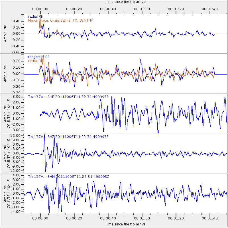
Signal To Noise
| Channel | StoN | STA | LTA |
| TA:137A: :BHZ:20111006T11:22:31.499993Z | 13.922143 | 5.237506E-6 | 3.7619967E-7 |
| TA:137A: :BHN:20111006T11:22:31.499993Z | 1.715041 | 9.515235E-7 | 5.548109E-7 |
| TA:137A: :BHE:20111006T11:22:31.499993Z | 0.97936183 | 5.1095765E-7 | 5.217251E-7 |
| Arrivals |
| Ps | 1.8 SECOND |
| PpPs | 5.0 SECOND |
| PsPs/PpSs | 6.7 SECOND |


