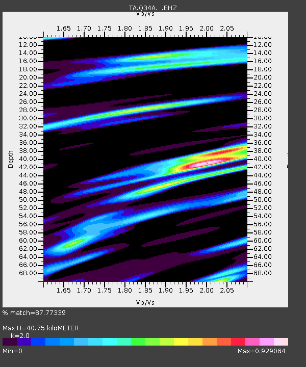
Q34A Chapman, KS, USA - Earthquake Result Viewer
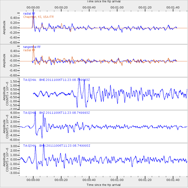
Earthquake location: Salta Province, Argentina
Earthquake latitude/longitude: -24.2/-64.2
Earthquake time(UTC): 2011/10/06 (279) 11:12:30 GMT
Earthquake Depth: 15 km
Earthquake Magnitude: 6.5 MB, 5.7 MS, 6.1 MW, 5.9 MW
Earthquake Catalog/Contributor: WHDF/NEIC
Network: TA USArray Transportable Network (new EarthScope stations)
Station: Q34A Chapman, KS, USA
Lat/Lon: 38.92 N/96.94 W
Elevation: 378 m
Distance: 69.8 deg
Az: 333.309 deg
Baz: 148.272 deg
Ray Param: 0.055365045
Estimated Moho Depth: 40.75 km
Estimated Crust Vp/Vs: 2.00
Assumed Crust Vp: 6.483 km/s
Estimated Crust Vs: 3.241 km/s
Estimated Crust Poisson's Ratio: 0.33
Radial Match: 87.77339 %
Radial Bump: 400
Transverse Match: 73.71142 %
Transverse Bump: 400
SOD ConfigId: 424168
Insert Time: 2012-02-04 05:38:05.017 +0000
GWidth: 2.5
Max Bumps: 400
Tol: 0.001

Signal To Noise

ChannelStoNSTALTA
TA:Q34A: :BHZ:20111006T11:23:08.749993Z17.7142162.6047555E-61.4704324E-7
TA:Q34A: :BHN:20111006T11:23:08.749993Z4.90011261.2515051E-62.5540334E-7
TA:Q34A: :BHE:20111006T11:23:08.749993Z5.829379.531102E-71.6350141E-7
Arrivals
Ps6.5 SECOND
PpPs18 SECOND
PsPs/PpSs25 SECOND