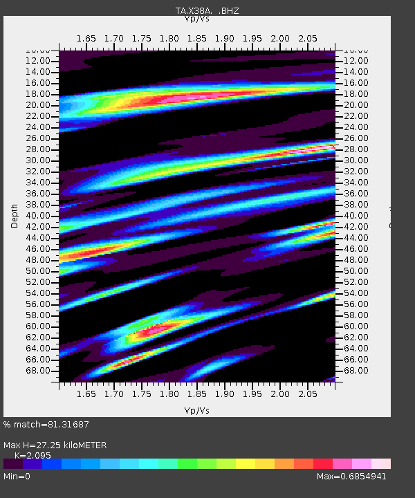
X38A Whitesboro, OK, USA - Earthquake Result Viewer

Earthquake location: Salta Province, Argentina
Earthquake latitude/longitude: -24.2/-64.2
Earthquake time(UTC): 2011/10/06 (279) 11:12:30 GMT
Earthquake Depth: 15 km
Earthquake Magnitude: 6.5 MB, 5.7 MS, 6.1 MW, 5.9 MW
Earthquake Catalog/Contributor: WHDF/NEIC
Network: TA USArray Transportable Network (new EarthScope stations)
Station: X38A Whitesboro, OK, USA
Lat/Lon: 34.67 N/94.83 W
Elevation: 234 m
Distance: 65.3 deg
Az: 332.496 deg
Baz: 149.222 deg
Ray Param: 0.058326215
Estimated Moho Depth: 27.25 km
Estimated Crust Vp/Vs: 2.10
Assumed Crust Vp: 6.498 km/s
Estimated Crust Vs: 3.101 km/s
Estimated Crust Poisson's Ratio: 0.35
Radial Match: 81.31687 %
Radial Bump: 400
Transverse Match: 65.89914 %
Transverse Bump: 391
SOD ConfigId: 424168
Insert Time: 2012-02-04 05:40:36.841 +0000
GWidth: 2.5
Max Bumps: 400
Tol: 0.001

Signal To Noise

ChannelStoNSTALTA
TA:X38A: :BHZ:20111006T11:22:40.350029Z11.793613.2484477E-62.7544132E-7
TA:X38A: :BHN:20111006T11:22:40.350029Z2.21191761.1227266E-65.0758064E-7
TA:X38A: :BHE:20111006T11:22:40.350029Z1.85797816.9733136E-73.753173E-7
Arrivals
Ps4.8 SECOND
PpPs13 SECOND
PsPs/PpSs17 SECOND