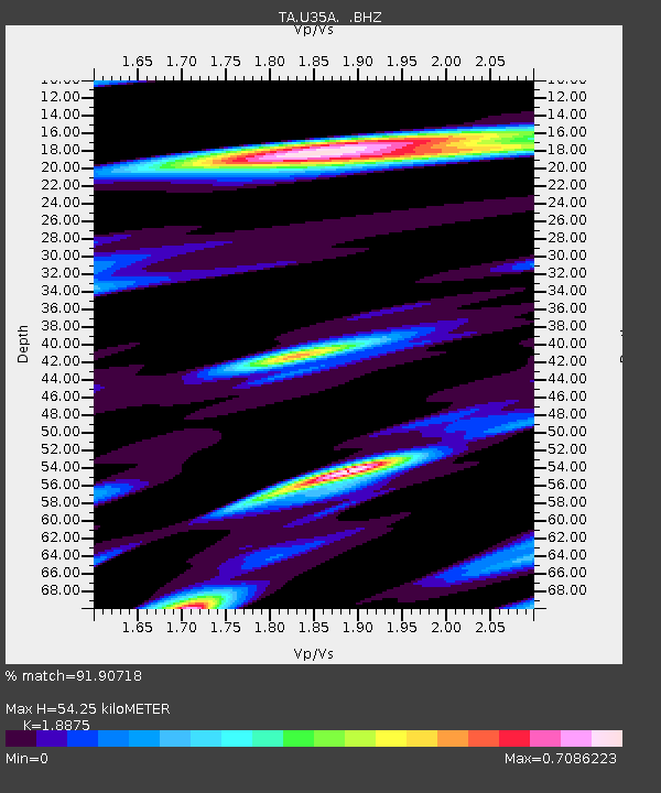
U35A Pawnee, OK, USA - Earthquake Result Viewer

Earthquake location: Salta Province, Argentina
Earthquake latitude/longitude: -24.2/-64.2
Earthquake time(UTC): 2011/10/06 (279) 11:12:30 GMT
Earthquake Depth: 15 km
Earthquake Magnitude: 6.5 MB, 5.7 MS, 6.1 MW, 5.9 MW
Earthquake Catalog/Contributor: WHDF/NEIC
Network: TA USArray Transportable Network (new EarthScope stations)
Station: U35A Pawnee, OK, USA
Lat/Lon: 36.37 N/96.73 W
Elevation: 303 m
Distance: 67.6 deg
Az: 332.017 deg
Baz: 147.93 deg
Ray Param: 0.05684239
Estimated Moho Depth: 54.25 km
Estimated Crust Vp/Vs: 1.89
Assumed Crust Vp: 6.483 km/s
Estimated Crust Vs: 3.434 km/s
Estimated Crust Poisson's Ratio: 0.30
Radial Match: 91.90718 %
Radial Bump: 400
Transverse Match: 71.3805 %
Transverse Bump: 400
SOD ConfigId: 424168
Insert Time: 2012-02-04 05:41:53.302 +0000
GWidth: 2.5
Max Bumps: 400
Tol: 0.001

Signal To Noise

ChannelStoNSTALTA
TA:U35A: :BHZ:20111006T11:22:54.775017Z17.6939013.86367E-62.1836168E-7
TA:U35A: :BHN:20111006T11:22:54.775017Z14.2201621.915156E-61.3467891E-7
TA:U35A: :BHE:20111006T11:22:54.775017Z5.6946761.0314692E-61.8112868E-7
Arrivals
Ps7.7 SECOND
PpPs23 SECOND
PsPs/PpSs31 SECOND