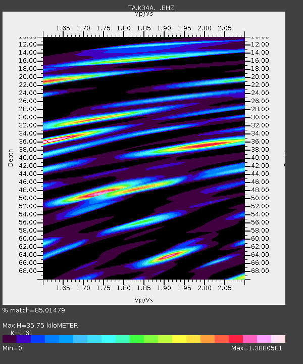
K34A Le Mars, IA, USA - Earthquake Result Viewer

Earthquake location: Salta Province, Argentina
Earthquake latitude/longitude: -24.2/-64.2
Earthquake time(UTC): 2011/10/06 (279) 11:12:30 GMT
Earthquake Depth: 15 km
Earthquake Magnitude: 6.5 MB, 5.7 MS, 6.1 MW, 5.9 MW
Earthquake Catalog/Contributor: WHDF/NEIC
Network: TA USArray Transportable Network (new EarthScope stations)
Station: K34A Le Mars, IA, USA
Lat/Lon: 42.69 N/96.10 W
Elevation: 436 m
Distance: 72.7 deg
Az: 335.937 deg
Baz: 149.665 deg
Ray Param: 0.05345293
Estimated Moho Depth: 35.75 km
Estimated Crust Vp/Vs: 1.61
Assumed Crust Vp: 6.498 km/s
Estimated Crust Vs: 4.036 km/s
Estimated Crust Poisson's Ratio: 0.19
Radial Match: 85.01479 %
Radial Bump: 400
Transverse Match: 65.65343 %
Transverse Bump: 400
SOD ConfigId: 424168
Insert Time: 2012-02-04 05:43:08.441 +0000
GWidth: 2.5
Max Bumps: 400
Tol: 0.001

Signal To Noise

ChannelStoNSTALTA
TA:K34A: :BHZ:20111006T11:23:26.200005Z8.6265752.414652E-62.799085E-7
TA:K34A: :BHN:20111006T11:23:26.200005Z4.55066351.2882001E-62.8307963E-7
TA:K34A: :BHE:20111006T11:23:26.200005Z3.624037.017712E-71.9364388E-7
Arrivals
Ps3.5 SECOND
PpPs14 SECOND
PsPs/PpSs17 SECOND