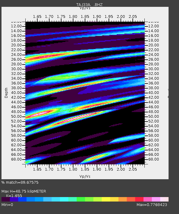
J33A Davis, SD, USA - Earthquake Result Viewer

Earthquake location: Salta Province, Argentina
Earthquake latitude/longitude: -24.2/-64.2
Earthquake time(UTC): 2011/10/06 (279) 11:12:30 GMT
Earthquake Depth: 15 km
Earthquake Magnitude: 6.5 MB, 5.7 MS, 6.1 MW, 5.9 MW
Earthquake Catalog/Contributor: WHDF/NEIC
Network: TA USArray Transportable Network (new EarthScope stations)
Station: J33A Davis, SD, USA
Lat/Lon: 43.32 N/96.97 W
Elevation: 400 m
Distance: 73.6 deg
Az: 335.699 deg
Baz: 149.004 deg
Ray Param: 0.052880827
Estimated Moho Depth: 48.75 km
Estimated Crust Vp/Vs: 1.65
Assumed Crust Vp: 6.498 km/s
Estimated Crust Vs: 3.926 km/s
Estimated Crust Poisson's Ratio: 0.21
Radial Match: 89.67575 %
Radial Bump: 400
Transverse Match: 73.97447 %
Transverse Bump: 400
SOD ConfigId: 424168
Insert Time: 2012-02-04 05:43:11.752 +0000
GWidth: 2.5
Max Bumps: 400
Tol: 0.001

Signal To Noise

ChannelStoNSTALTA
TA:J33A: :BHZ:20111006T11:23:31.325005Z12.3942152.5592503E-62.0648751E-7
TA:J33A: :BHN:20111006T11:23:31.325005Z7.5867041.1944212E-61.5743612E-7
TA:J33A: :BHE:20111006T11:23:31.325005Z5.5570956.52538E-71.1742429E-7
Arrivals
Ps5.1 SECOND
PpPs19 SECOND
PsPs/PpSs24 SECOND