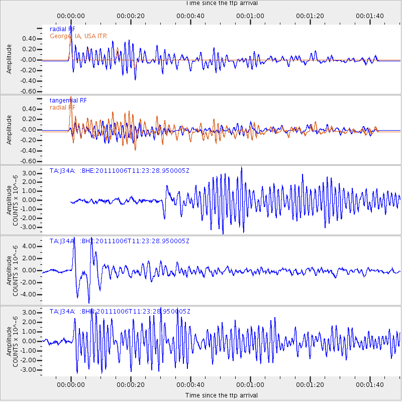
J34A George, IA, USA - Earthquake Result Viewer
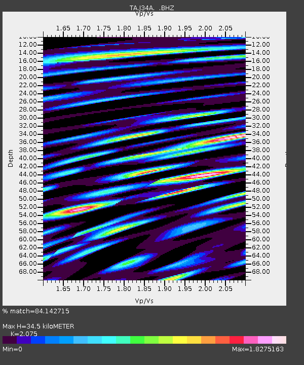
Earthquake location: Salta Province, Argentina
Earthquake latitude/longitude: -24.2/-64.2
Earthquake time(UTC): 2011/10/06 (279) 11:12:30 GMT
Earthquake Depth: 15 km
Earthquake Magnitude: 6.5 MB, 5.7 MS, 6.1 MW, 5.9 MW
Earthquake Catalog/Contributor: WHDF/NEIC
Network: TA USArray Transportable Network (new EarthScope stations)
Station: J34A George, IA, USA
Lat/Lon: 43.28 N/95.96 W
Elevation: 432 m
Distance: 73.2 deg
Az: 336.343 deg
Baz: 149.878 deg
Ray Param: 0.053148
Estimated Moho Depth: 34.5 km
Estimated Crust Vp/Vs: 2.08
Assumed Crust Vp: 6.53 km/s
Estimated Crust Vs: 3.147 km/s
Estimated Crust Poisson's Ratio: 0.35
Radial Match: 84.142715 %
Radial Bump: 400
Transverse Match: 79.99642 %
Transverse Bump: 400
SOD ConfigId: 424168
Insert Time: 2012-02-04 05:43:52.220 +0000
GWidth: 2.5
Max Bumps: 400
Tol: 0.001

Signal To Noise

ChannelStoNSTALTA
TA:J34A: :BHZ:20111006T11:23:28.950005Z10.9406132.2733868E-62.0779338E-7
TA:J34A: :BHN:20111006T11:23:28.950005Z5.3030611.308119E-62.466724E-7
TA:J34A: :BHE:20111006T11:23:28.950005Z4.8409238.2231617E-71.6986763E-7
Arrivals
Ps5.9 SECOND
PpPs16 SECOND
PsPs/PpSs22 SECOND