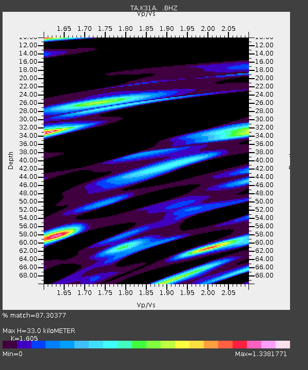
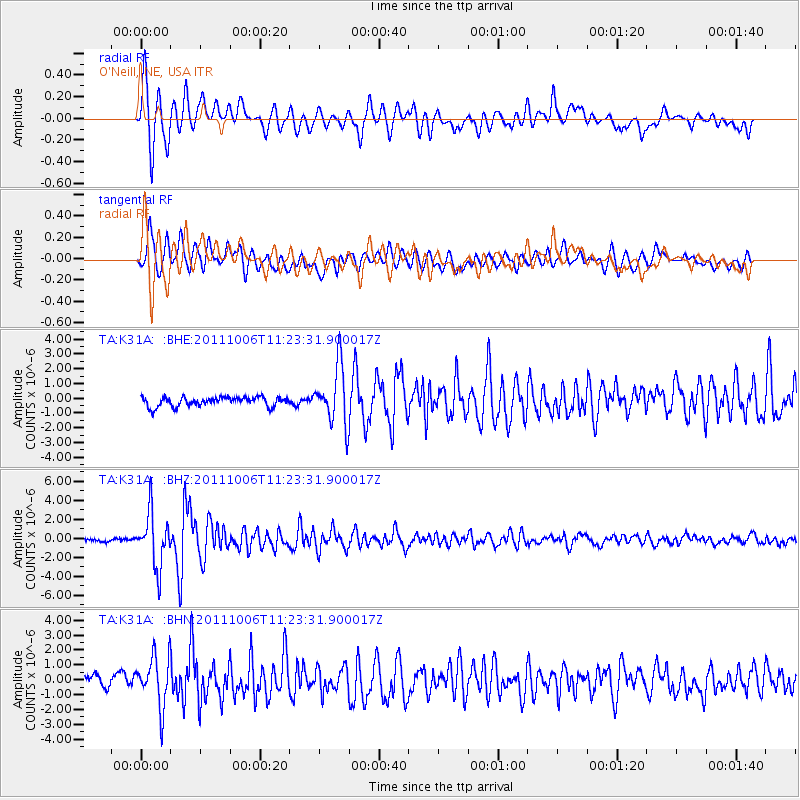
K31A O'Neill, NE, USA - Earthquake Result Viewer

Earthquake location: Salta Province, Argentina
Earthquake latitude/longitude: -24.2/-64.2
Earthquake time(UTC): 2011/10/06 (279) 11:12:30 GMT
Earthquake Depth: 15 km
Earthquake Magnitude: 6.5 MB, 5.7 MS, 6.1 MW, 5.9 MW
Earthquake Catalog/Contributor: WHDF/NEIC
Network: TA USArray Transportable Network (new EarthScope stations)
Station: K31A O'Neill, NE, USA
Lat/Lon: 42.62 N/98.75 W
Elevation: 580 m
Distance: 73.7 deg
Az: 334.155 deg
Baz: 147.356 deg
Ray Param: 0.052813392
Estimated Moho Depth: 33.0 km
Estimated Crust Vp/Vs: 1.61
Assumed Crust Vp: 6.53 km/s
Estimated Crust Vs: 4.069 km/s
Estimated Crust Poisson's Ratio: 0.18
Radial Match: 87.30377 %
Radial Bump: 400
Transverse Match: 78.45486 %
Transverse Bump: 400
SOD ConfigId: 424168
Insert Time: 2012-02-04 05:45:32.016 +0000
GWidth: 2.5
Max Bumps: 400
Tol: 0.001

Signal To Noise

ChannelStoNSTALTA
TA:K31A: :BHZ:20111006T11:23:31.900017Z11.85839752.8348156E-62.3905554E-7
TA:K31A: :BHN:20111006T11:23:31.900017Z3.21629451.7046472E-65.3000343E-7
TA:K31A: :BHE:20111006T11:23:31.900017Z6.26641851.9682957E-63.1410218E-7
Arrivals
Ps3.2 SECOND
PpPs13 SECOND
PsPs/PpSs16 SECOND