You are here: Home > Network List > TA - USArray Transportable Network (new EarthScope stations) Stations List
> Station I36A Fitzsimmons Farm, Good Thunder, MN, USA > Earthquake Result Viewer
I36A Fitzsimmons Farm, Good Thunder, MN, USA - Earthquake Result Viewer

| Earthquake location: |
Salta Province, Argentina |
| Earthquake latitude/longitude: |
-24.2/-64.2 |
| Earthquake time(UTC): |
2011/10/06 (279) 11:12:30 GMT |
| Earthquake Depth: |
15 km |
| Earthquake Magnitude: |
6.5 MB, 5.7 MS, 6.1 MW, 5.9 MW |
| Earthquake Catalog/Contributor: |
WHDF/NEIC |
|
| Network: |
TA USArray Transportable Network (new EarthScope stations) |
| Station: |
I36A Fitzsimmons Farm, Good Thunder, MN, USA |
| Lat/Lon: |
44.02 N/94.01 W |
| Elevation: |
307 m |
|
| Distance: |
73.2 deg |
| Az: |
338.003 deg |
| Baz: |
151.695 deg |
| Ray Param: |
0.053179182 |
| Estimated Moho Depth: |
55.0 km |
| Estimated Crust Vp/Vs: |
1.97 |
| Assumed Crust Vp: |
6.571 km/s |
| Estimated Crust Vs: |
3.335 km/s |
| Estimated Crust Poisson's Ratio: |
0.33 |
|
| Radial Match: |
84.78246 % |
| Radial Bump: |
400 |
| Transverse Match: |
80.80005 % |
| Transverse Bump: |
400 |
| SOD ConfigId: |
424168 |
| Insert Time: |
2012-02-04 05:49:22.511 +0000 |
| GWidth: |
2.5 |
| Max Bumps: |
400 |
| Tol: |
0.001 |
|
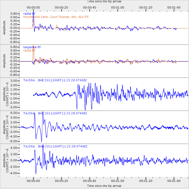
Signal To Noise
| Channel | StoN | STA | LTA |
| TA:I36A: :BHZ:20111006T11:23:28.67498Z | 5.585408 | 2.4218587E-6 | 4.3360458E-7 |
| TA:I36A: :BHN:20111006T11:23:28.67498Z | 4.529448 | 1.6503394E-6 | 3.6435773E-7 |
| TA:I36A: :BHE:20111006T11:23:28.67498Z | 4.477531 | 1.2596156E-6 | 2.8131922E-7 |
| Arrivals |
| Ps | 8.4 SECOND |
| PpPs | 24 SECOND |
| PsPs/PpSs | 32 SECOND |


