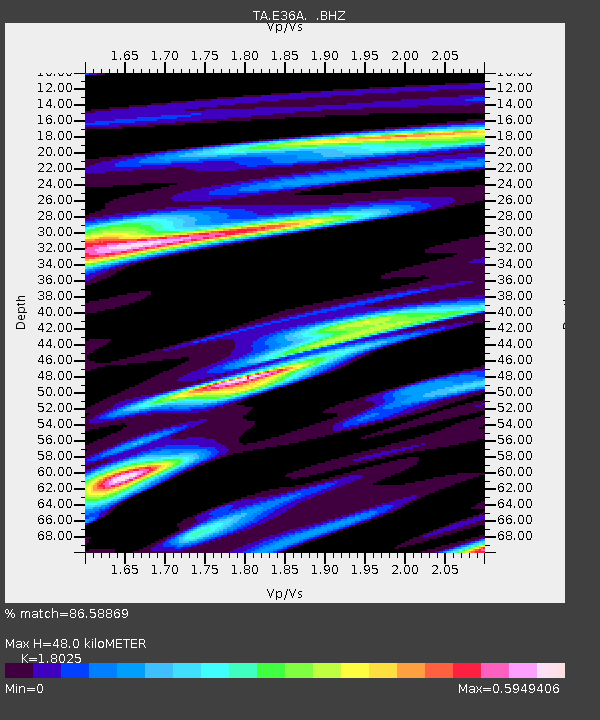
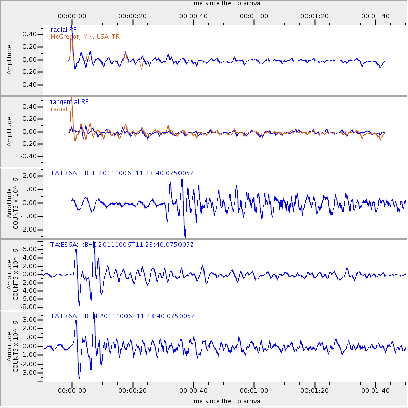
E36A McGregor, MN, USA - Earthquake Result Viewer

Earthquake location: Salta Province, Argentina
Earthquake latitude/longitude: -24.2/-64.2
Earthquake time(UTC): 2011/10/06 (279) 11:12:30 GMT
Earthquake Depth: 15 km
Earthquake Magnitude: 6.5 MB, 5.7 MS, 6.1 MW, 5.9 MW
Earthquake Catalog/Contributor: WHDF/NEIC
Network: TA USArray Transportable Network (new EarthScope stations)
Station: E36A McGregor, MN, USA
Lat/Lon: 46.52 N/93.26 W
Elevation: 393 m
Distance: 75.1 deg
Az: 339.708 deg
Baz: 152.698 deg
Ray Param: 0.051871702
Estimated Moho Depth: 48.0 km
Estimated Crust Vp/Vs: 1.80
Assumed Crust Vp: 6.571 km/s
Estimated Crust Vs: 3.645 km/s
Estimated Crust Poisson's Ratio: 0.28
Radial Match: 86.58869 %
Radial Bump: 281
Transverse Match: 73.01057 %
Transverse Bump: 379
SOD ConfigId: 424168
Insert Time: 2012-02-04 05:50:49.450 +0000
GWidth: 2.5
Max Bumps: 400
Tol: 0.001

Signal To Noise

ChannelStoNSTALTA
TA:E36A: :BHZ:20111006T11:23:40.075005Z7.10092162.9141797E-64.1039456E-7
TA:E36A: :BHN:20111006T11:23:40.075005Z9.1947211.538059E-61.6727631E-7
TA:E36A: :BHE:20111006T11:23:40.075005Z2.92783386.3200775E-72.158619E-7
Arrivals
Ps6.1 SECOND
PpPs20 SECOND
PsPs/PpSs26 SECOND