You are here: Home > Network List > CI - Caltech Regional Seismic Network Stations List
> Station LGU Laguna Peak, California, USA > Earthquake Result Viewer
LGU Laguna Peak, California, USA - Earthquake Result Viewer

| Earthquake location: |
South Of Aleutian Islands |
| Earthquake latitude/longitude: |
51.8/-166.3 |
| Earthquake time(UTC): |
2004/08/07 (220) 09:30:16 GMT |
| Earthquake Depth: |
8.0 km |
| Earthquake Magnitude: |
6.3 MB, 5.4 MS, 6.0 MW, 6.0 MW |
| Earthquake Catalog/Contributor: |
WHDF/NEIC |
|
| Network: |
CI Caltech Regional Seismic Network |
| Station: |
LGU Laguna Peak, California, USA |
| Lat/Lon: |
34.11 N/119.07 W |
| Elevation: |
381 m |
|
| Distance: |
38.1 deg |
| Az: |
98.792 deg |
| Baz: |
312.236 deg |
| Ray Param: |
0.07578475 |
| Estimated Moho Depth: |
10.0 km |
| Estimated Crust Vp/Vs: |
1.60 |
| Assumed Crust Vp: |
6.1 km/s |
| Estimated Crust Vs: |
3.812 km/s |
| Estimated Crust Poisson's Ratio: |
0.18 |
|
| Radial Match: |
91.038414 % |
| Radial Bump: |
400 |
| Transverse Match: |
71.15865 % |
| Transverse Bump: |
400 |
| SOD ConfigId: |
2459 |
| Insert Time: |
2010-02-25 20:18:46.738 +0000 |
| GWidth: |
2.5 |
| Max Bumps: |
400 |
| Tol: |
0.001 |
|
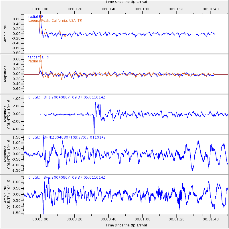
Signal To Noise
| Channel | StoN | STA | LTA |
| CI:LGU: :BHN:20040807T09:37:05.011014Z | 5.203943 | 6.590067E-7 | 1.2663602E-7 |
| CI:LGU: :BHE:20040807T09:37:05.011014Z | 4.28952 | 5.665419E-7 | 1.3207584E-7 |
| CI:LGU: :BHZ:20040807T09:37:05.011014Z | 14.879203 | 1.7432371E-6 | 1.1715931E-7 |
| Arrivals |
| Ps | 1.1 SECOND |
| PpPs | 4.0 SECOND |
| PsPs/PpSs | 5.0 SECOND |


