You are here: Home > Network List > 1U - Mt. Paektu Seismic Network Stations List
> Station SHRD Sin Hung Ri > Earthquake Result Viewer
SHRD Sin Hung Ri - Earthquake Result Viewer
| Earthquake location: |
Solomon Islands |
| Earthquake latitude/longitude: |
-11.3/162.2 |
| Earthquake time(UTC): |
2014/04/12 (102) 20:14:39 GMT |
| Earthquake Depth: |
29 km |
| Earthquake Magnitude: |
7.6 MWW, 8.3 MI |
| Earthquake Catalog/Contributor: |
NEIC PDE/NEIC COMCAT |
|
| Network: |
1U Mt. Paektu Seismic Network |
| Station: |
SHRD Sin Hung Ri |
| Lat/Lon: |
41.95 N/128.79 E |
| Elevation: |
1041 m |
|
| Distance: |
61.3 deg |
| Az: |
332.055 deg |
| Baz: |
141.966 deg |
| Ray Param: |
0.060944792 |
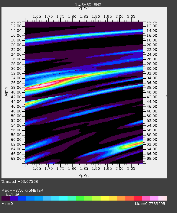
| Estimated Moho Depth: |
37.0 km |
| Estimated Crust Vp/Vs: |
1.66 |
| Assumed Crust Vp: |
6.472 km/s |
| Estimated Crust Vs: |
3.899 km/s |
| Estimated Crust Poisson's Ratio: |
0.22 |
|
| Radial Match: |
93.67568 % |
| Radial Bump: |
381 |
| Transverse Match: |
68.21017 % |
| Transverse Bump: |
400 |
| SOD ConfigId: |
3390531 |
| Insert Time: |
2019-04-11 08:04:39.501 +0000 |
| GWidth: |
2.5 |
| Max Bumps: |
400 |
| Tol: |
0.001 |
|

Signal To Noise
| Channel | StoN | STA | LTA |
| 1U:SHRD: :BHZ:20140412T20:24:21.279973Z | 57.45281 | 9.38947E-6 | 1.6342925E-7 |
| 1U:SHRD: :BHN:20140412T20:24:21.279973Z | 32.070087 | 3.1344748E-6 | 9.773827E-8 |
| 1U:SHRD: :BHE:20140412T20:24:21.279973Z | 31.73586 | 2.5601705E-6 | 8.0671214E-8 |
| Arrivals |
| Ps | 4.0 SECOND |
| PpPs | 14 SECOND |
| PsPs/PpSs | 18 SECOND |


