You are here: Home > Network List > TA - USArray Transportable Network (new EarthScope stations) Stations List
> Station R39A Chumby, Stover, MO, USA > Earthquake Result Viewer
R39A Chumby, Stover, MO, USA - Earthquake Result Viewer
| Earthquake location: |
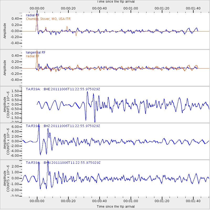
Salta Province, Argentina |
| Earthquake latitude/longitude: |
-24.2/-64.2 |
| Earthquake time(UTC): |
2011/10/06 (279) 11:12:30 GMT |
| Earthquake Depth: |
15 km |
| Earthquake Magnitude: |
6.5 MB, 5.7 MS, 6.1 MW, 5.9 MW |
| Earthquake Catalog/Contributor: |
WHDF/NEIC |
|
| Network: |
TA USArray Transportable Network (new EarthScope stations) |
| Station: |
R39A Chumby, Stover, MO, USA |
| Lat/Lon: |
38.31 N/93.04 W |
| Elevation: |
290 m |
|
| Distance: |
67.8 deg |
| Az: |
335.821 deg |
| Baz: |
151.606 deg |
| Ray Param: |
0.05671668 |
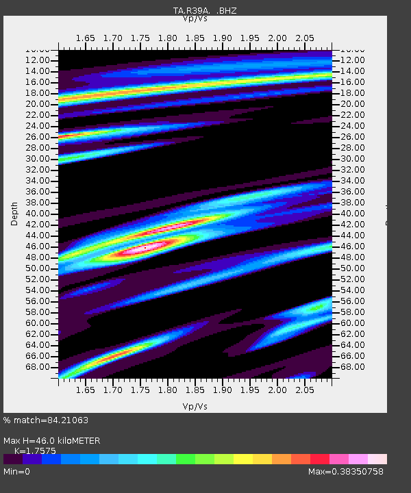
| Estimated Moho Depth: |
46.0 km |
| Estimated Crust Vp/Vs: |
1.76 |
| Assumed Crust Vp: |
6.498 km/s |
| Estimated Crust Vs: |
3.697 km/s |
| Estimated Crust Poisson's Ratio: |
0.26 |
|
| Radial Match: |
84.21063 % |
| Radial Bump: |
381 |
| Transverse Match: |
70.73075 % |
| Transverse Bump: |
400 |
| SOD ConfigId: |
424168 |
| Insert Time: |
2012-02-04 05:53:37.365 +0000 |
| GWidth: |
2.5 |
| Max Bumps: |
400 |
| Tol: |
0.001 |
|
Signal To Noise
| Channel | StoN | STA | LTA |
| TA:R39A: :BHZ:20111006T11:22:55.975029Z | 9.251516 | 3.1769498E-6 | 3.4339774E-7 |
| TA:R39A: :BHN:20111006T11:22:55.975029Z | 2.625659 | 1.0679702E-6 | 4.067437E-7 |
| TA:R39A: :BHE:20111006T11:22:55.975029Z | 2.7066154 | 7.2572766E-7 | 2.6813106E-7 |
| Arrivals |
| Ps | 5.6 SECOND |
| PpPs | 19 SECOND |
| PsPs/PpSs | 24 SECOND |


