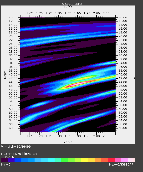
S39A Bolivar, MO, USA - Earthquake Result Viewer

Earthquake location: Salta Province, Argentina
Earthquake latitude/longitude: -24.2/-64.2
Earthquake time(UTC): 2011/10/06 (279) 11:12:30 GMT
Earthquake Depth: 15 km
Earthquake Magnitude: 6.5 MB, 5.7 MS, 6.1 MW, 5.9 MW
Earthquake Catalog/Contributor: WHDF/NEIC
Network: TA USArray Transportable Network (new EarthScope stations)
Station: S39A Bolivar, MO, USA
Lat/Lon: 37.69 N/93.32 W
Elevation: 331 m
Distance: 67.4 deg
Az: 335.286 deg
Baz: 151.227 deg
Ray Param: 0.057002477
Estimated Moho Depth: 44.75 km
Estimated Crust Vp/Vs: 1.90
Assumed Crust Vp: 6.53 km/s
Estimated Crust Vs: 3.437 km/s
Estimated Crust Poisson's Ratio: 0.31
Radial Match: 80.56499 %
Radial Bump: 250
Transverse Match: 68.148674 %
Transverse Bump: 400
SOD ConfigId: 424168
Insert Time: 2012-02-04 05:53:49.525 +0000
GWidth: 2.5
Max Bumps: 400
Tol: 0.001

Signal To Noise

ChannelStoNSTALTA
TA:S39A: :BHZ:20111006T11:22:53.225029Z10.4459443.279046E-63.1390616E-7
TA:S39A: :BHN:20111006T11:22:53.225029Z6.54747251.38743E-62.1190314E-7
TA:S39A: :BHE:20111006T11:22:53.225029Z4.53280168.3294583E-71.837596E-7
Arrivals
Ps6.4 SECOND
PpPs19 SECOND
PsPs/PpSs26 SECOND