You are here: Home > Network List > TA - USArray Transportable Network (new EarthScope stations) Stations List
> Station W40A Ferguson Farm, Pottsville, AR, USA > Earthquake Result Viewer
W40A Ferguson Farm, Pottsville, AR, USA - Earthquake Result Viewer
| Earthquake location: |
Salta Province, Argentina |
| Earthquake latitude/longitude: |
-24.2/-64.2 |
| Earthquake time(UTC): |
2011/10/06 (279) 11:12:30 GMT |
| Earthquake Depth: |
15 km |
| Earthquake Magnitude: |
6.5 MB, 5.7 MS, 6.1 MW, 5.9 MW |
| Earthquake Catalog/Contributor: |
WHDF/NEIC |
|
| Network: |
TA USArray Transportable Network (new EarthScope stations) |
| Station: |
W40A Ferguson Farm, Pottsville, AR, USA |
| Lat/Lon: |
35.19 N/93.07 W |
| Elevation: |
108 m |
|
| Distance: |
65.1 deg |
| Az: |
334.163 deg |
| Baz: |
150.924 deg |
| Ray Param: |
0.058502853 |
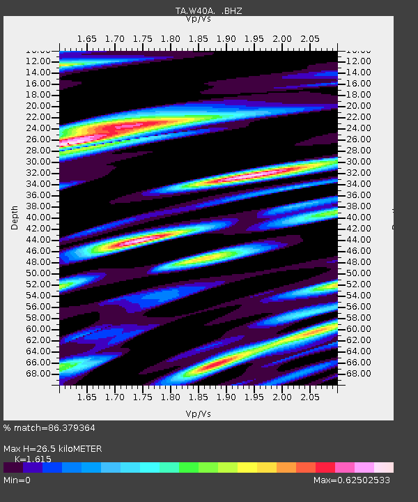
| Estimated Moho Depth: |
26.5 km |
| Estimated Crust Vp/Vs: |
1.62 |
| Assumed Crust Vp: |
6.498 km/s |
| Estimated Crust Vs: |
4.023 km/s |
| Estimated Crust Poisson's Ratio: |
0.19 |
|
| Radial Match: |
86.379364 % |
| Radial Bump: |
400 |
| Transverse Match: |
67.83119 % |
| Transverse Bump: |
400 |
| SOD ConfigId: |
424168 |
| Insert Time: |
2012-02-04 05:54:34.080 +0000 |
| GWidth: |
2.5 |
| Max Bumps: |
400 |
| Tol: |
0.001 |
|
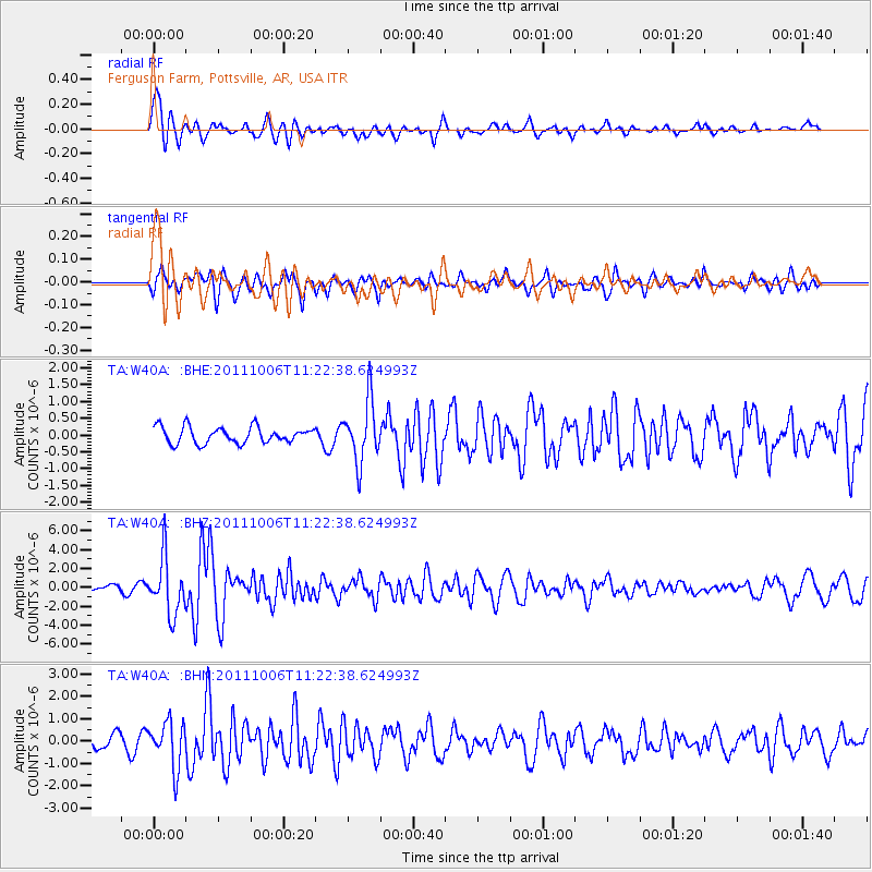
Signal To Noise
| Channel | StoN | STA | LTA |
| TA:W40A: :BHZ:20111006T11:22:38.624993Z | 7.628825 | 2.9538176E-6 | 3.8719168E-7 |
| TA:W40A: :BHN:20111006T11:22:38.624993Z | 3.1101766 | 1.0221753E-6 | 3.286551E-7 |
| TA:W40A: :BHE:20111006T11:22:38.624993Z | 3.7465477 | 9.016673E-7 | 2.4066617E-7 |
| Arrivals |
| Ps | 2.6 SECOND |
| PpPs | 10 SECOND |
| PsPs/PpSs | 13 SECOND |


