You are here: Home > Network List > TA - USArray Transportable Network (new EarthScope stations) Stations List
> Station U39A Green Forest, AR, USA > Earthquake Result Viewer
U39A Green Forest, AR, USA - Earthquake Result Viewer
*The percent match for this event was below the threshold and hence no stack was calculated.
| Earthquake location: |
Salta Province, Argentina |
| Earthquake latitude/longitude: |
-24.2/-64.2 |
| Earthquake time(UTC): |
2011/10/06 (279) 11:12:30 GMT |
| Earthquake Depth: |
15 km |
| Earthquake Magnitude: |
6.5 MB, 5.7 MS, 6.1 MW, 5.9 MW |
| Earthquake Catalog/Contributor: |
WHDF/NEIC |
|
| Network: |
TA USArray Transportable Network (new EarthScope stations) |
| Station: |
U39A Green Forest, AR, USA |
| Lat/Lon: |
36.38 N/93.48 W |
| Elevation: |
433 m |
|
| Distance: |
66.3 deg |
| Az: |
334.477 deg |
| Baz: |
150.814 deg |
| Ray Param: |
$rayparam |
*The percent match for this event was below the threshold and hence was not used in the summary stack. |
|
| Radial Match: |
70.57779 % |
| Radial Bump: |
360 |
| Transverse Match: |
60.776417 % |
| Transverse Bump: |
400 |
| SOD ConfigId: |
424168 |
| Insert Time: |
2012-02-04 05:55:04.970 +0000 |
| GWidth: |
2.5 |
| Max Bumps: |
400 |
| Tol: |
0.001 |
|
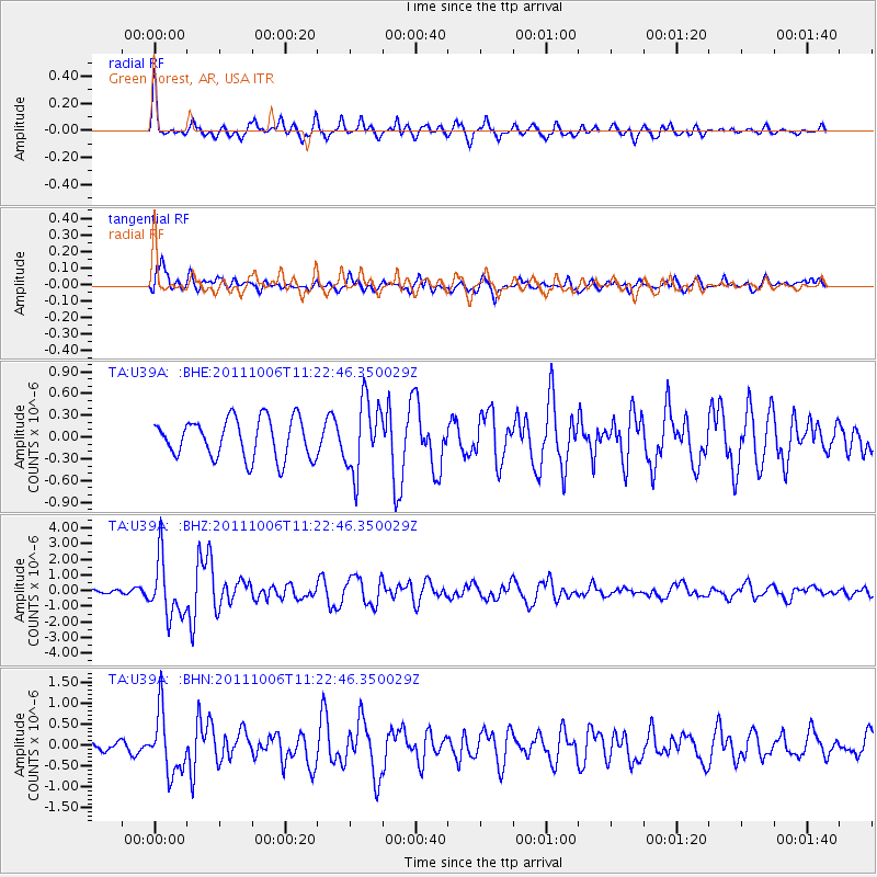
Signal To Noise
| Channel | StoN | STA | LTA |
| TA:U39A: :BHZ:20111006T11:22:46.350029Z | 7.071957 | 1.8416397E-6 | 2.6041445E-7 |
| TA:U39A: :BHN:20111006T11:22:46.350029Z | 6.6037273 | 7.18278E-7 | 1.0876857E-7 |
| TA:U39A: :BHE:20111006T11:22:46.350029Z | 1.8451891 | 4.9499346E-7 | 2.6826166E-7 |
| Arrivals |
| Ps | |
| PpPs | |
| PsPs/PpSs | |


