You are here: Home > Network List > TA - USArray Transportable Network (new EarthScope stations) Stations List
> Station Z40A Long Farm, Magnolia, AR, USA > Earthquake Result Viewer
Z40A Long Farm, Magnolia, AR, USA - Earthquake Result Viewer
| Earthquake location: |
Salta Province, Argentina |
| Earthquake latitude/longitude: |
-24.2/-64.2 |
| Earthquake time(UTC): |
2011/10/06 (279) 11:12:30 GMT |
| Earthquake Depth: |
15 km |
| Earthquake Magnitude: |
6.5 MB, 5.7 MS, 6.1 MW, 5.9 MW |
| Earthquake Catalog/Contributor: |
WHDF/NEIC |
|
| Network: |
TA USArray Transportable Network (new EarthScope stations) |
| Station: |
Z40A Long Farm, Magnolia, AR, USA |
| Lat/Lon: |
33.26 N/93.40 W |
| Elevation: |
78 m |
|
| Distance: |
63.5 deg |
| Az: |
332.846 deg |
| Baz: |
150.168 deg |
| Ray Param: |
0.059510093 |
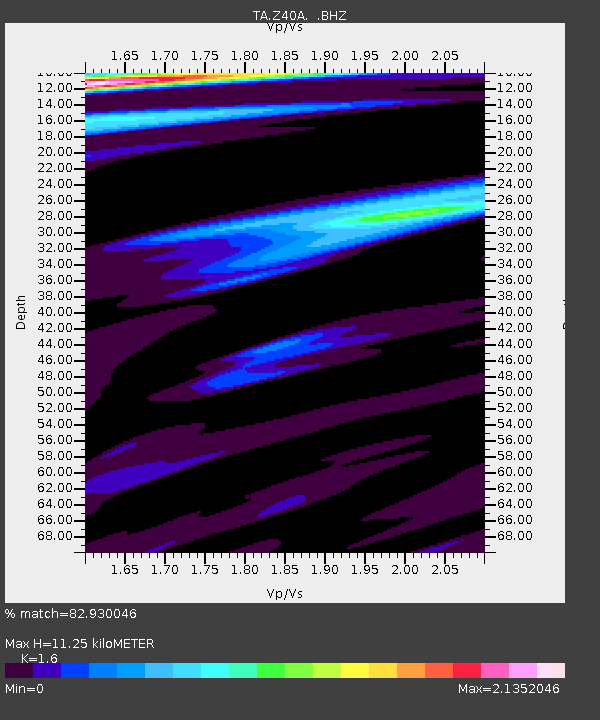
| Estimated Moho Depth: |
11.25 km |
| Estimated Crust Vp/Vs: |
1.60 |
| Assumed Crust Vp: |
6.245 km/s |
| Estimated Crust Vs: |
3.903 km/s |
| Estimated Crust Poisson's Ratio: |
0.18 |
|
| Radial Match: |
82.930046 % |
| Radial Bump: |
388 |
| Transverse Match: |
71.45683 % |
| Transverse Bump: |
391 |
| SOD ConfigId: |
424168 |
| Insert Time: |
2012-02-04 05:55:48.479 +0000 |
| GWidth: |
2.5 |
| Max Bumps: |
400 |
| Tol: |
0.001 |
|
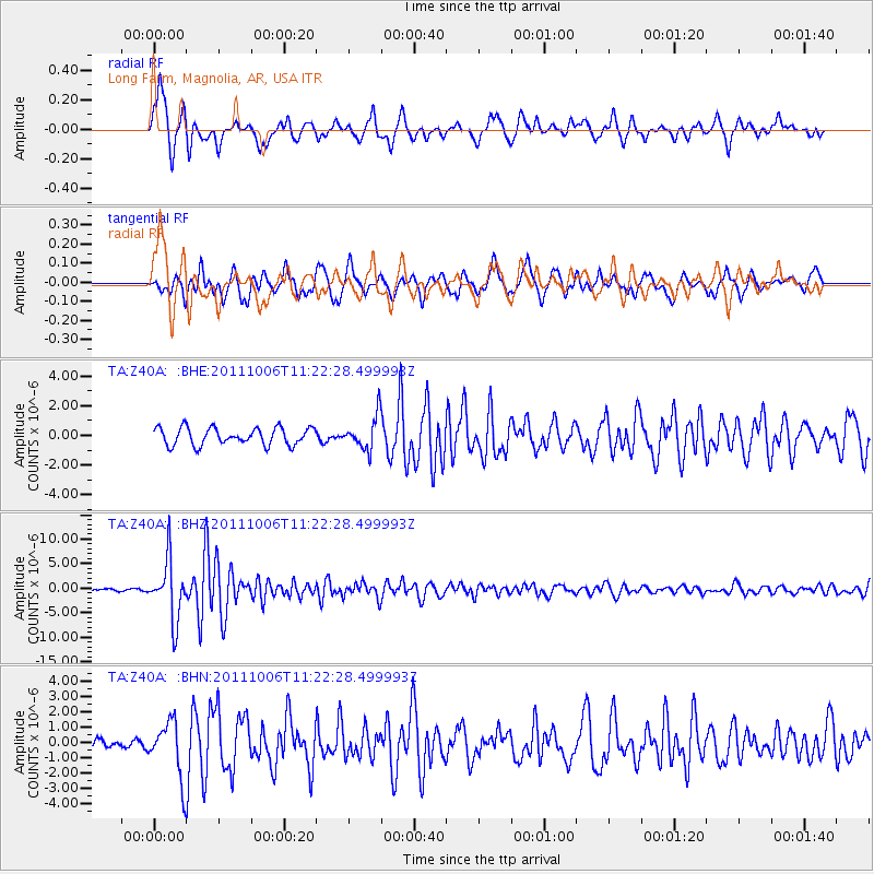
Signal To Noise
| Channel | StoN | STA | LTA |
| TA:Z40A: :BHZ:20111006T11:22:28.499993Z | 31.287544 | 6.0490106E-6 | 1.9333606E-7 |
| TA:Z40A: :BHN:20111006T11:22:28.499993Z | 3.7570167 | 1.8346053E-6 | 4.883144E-7 |
| TA:Z40A: :BHE:20111006T11:22:28.499993Z | 1.939922 | 1.1199865E-6 | 5.773358E-7 |
| Arrivals |
| Ps | 1.1 SECOND |
| PpPs | 4.5 SECOND |
| PsPs/PpSs | 5.6 SECOND |


