You are here: Home > Network List > TA - USArray Transportable Network (new EarthScope stations) Stations List
> Station 143A Socs Landing, Pioneer, LA, USA > Earthquake Result Viewer
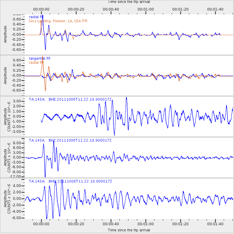
143A Socs Landing, Pioneer, LA, USA - Earthquake Result Viewer
| Earthquake location: |
Salta Province, Argentina |
| Earthquake latitude/longitude: |
-24.2/-64.2 |
| Earthquake time(UTC): |
2011/10/06 (279) 11:12:30 GMT |
| Earthquake Depth: |
15 km |
| Earthquake Magnitude: |
6.5 MB, 5.7 MS, 6.1 MW, 5.9 MW |
| Earthquake Catalog/Contributor: |
WHDF/NEIC |
|
| Network: |
TA USArray Transportable Network (new EarthScope stations) |
| Station: |
143A Socs Landing, Pioneer, LA, USA |
| Lat/Lon: |
32.70 N/91.40 W |
| Elevation: |
30 m |
|
| Distance: |
62.2 deg |
| Az: |
334.193 deg |
| Baz: |
151.864 deg |
| Ray Param: |
0.06035443 |
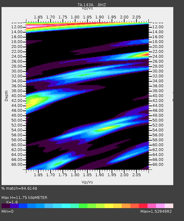
| Estimated Moho Depth: |
11.75 km |
| Estimated Crust Vp/Vs: |
1.60 |
| Assumed Crust Vp: |
6.201 km/s |
| Estimated Crust Vs: |
3.876 km/s |
| Estimated Crust Poisson's Ratio: |
0.18 |
|
| Radial Match: |
94.6146 % |
| Radial Bump: |
227 |
| Transverse Match: |
86.59879 % |
| Transverse Bump: |
368 |
| SOD ConfigId: |
424168 |
| Insert Time: |
2012-02-04 05:56:31.997 +0000 |
| GWidth: |
2.5 |
| Max Bumps: |
400 |
| Tol: |
0.001 |
|
Signal To Noise
| Channel | StoN | STA | LTA |
| TA:143A: :BHZ:20111006T11:22:19.900017Z | 28.356205 | 4.3917476E-6 | 1.5487784E-7 |
| TA:143A: :BHN:20111006T11:22:19.900017Z | 5.6063495 | 2.9449036E-6 | 5.252801E-7 |
| TA:143A: :BHE:20111006T11:22:19.900017Z | 3.2636213 | 1.2777127E-6 | 3.9150152E-7 |
| Arrivals |
| Ps | 1.2 SECOND |
| PpPs | 4.7 SECOND |
| PsPs/PpSs | 5.9 SECOND |


