You are here: Home > Network List > ER - Mount Erebus Volcano Observatory Seismic Network Stations List
> Station ICE Mt Erebus site ICE > Earthquake Result Viewer
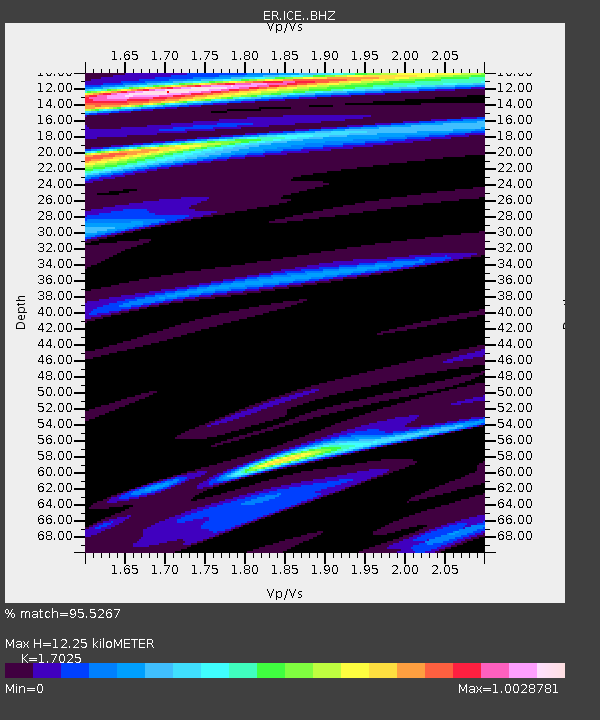
ICE Mt Erebus site ICE - Earthquake Result Viewer
| Earthquake location: |
Solomon Islands |
| Earthquake latitude/longitude: |
-11.3/162.2 |
| Earthquake time(UTC): |
2014/04/12 (102) 20:14:39 GMT |
| Earthquake Depth: |
29 km |
| Earthquake Magnitude: |
7.6 MWW, 8.3 MI |
| Earthquake Catalog/Contributor: |
NEIC PDE/NEIC COMCAT |
|
| Network: |
ER Mount Erebus Volcano Observatory Seismic Network |
| Station: |
ICE Mt Erebus site ICE |
| Lat/Lon: |
77.55 S/167.28 E |
| Elevation: |
2370 m |
|
| Distance: |
66.3 deg |
| Az: |
178.8 deg |
| Baz: |
354.566 deg |
| Ray Param: |
0.057675082 |
| Estimated Moho Depth: |
12.25 km |
| Estimated Crust Vp/Vs: |
1.70 |
| Assumed Crust Vp: |
6.183 km/s |
| Estimated Crust Vs: |
3.631 km/s |
| Estimated Crust Poisson's Ratio: |
0.24 |
|
| Radial Match: |
95.5267 % |
| Radial Bump: |
301 |
| Transverse Match: |
92.84925 % |
| Transverse Bump: |
400 |
| SOD ConfigId: |
3390531 |
| Insert Time: |
2019-04-11 08:06:07.506 +0000 |
| GWidth: |
2.5 |
| Max Bumps: |
400 |
| Tol: |
0.001 |
|

Signal To Noise
| Channel | StoN | STA | LTA |
| ER:ICE: :BHZ:20140412T20:24:55.250005Z | 3.494342 | 1.542652E-6 | 4.4147134E-7 |
| ER:ICE: :BHN:20140412T20:24:55.250005Z | 1.2717944 | 5.7705023E-7 | 4.537292E-7 |
| ER:ICE: :BHE:20140412T20:24:55.250005Z | 0.6839653 | 2.8797317E-7 | 4.2103474E-7 |
| Arrivals |
| Ps | 1.4 SECOND |
| PpPs | 5.1 SECOND |
| PsPs/PpSs | 6.6 SECOND |


