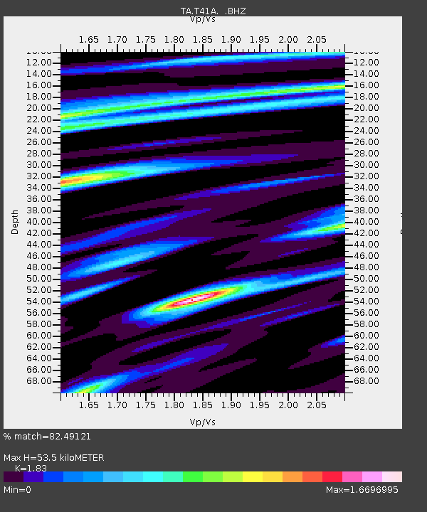
T41A Mountain View, MO, USA - Earthquake Result Viewer
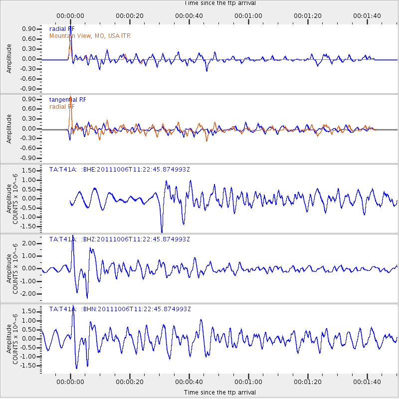
Earthquake location: Salta Province, Argentina
Earthquake latitude/longitude: -24.2/-64.2
Earthquake time(UTC): 2011/10/06 (279) 11:12:30 GMT
Earthquake Depth: 15 km
Earthquake Magnitude: 6.5 MB, 5.7 MS, 6.1 MW, 5.9 MW
Earthquake Catalog/Contributor: WHDF/NEIC
Network: TA USArray Transportable Network (new EarthScope stations)
Station: T41A Mountain View, MO, USA
Lat/Lon: 37.04 N/91.76 W
Elevation: 366 m
Distance: 66.2 deg
Az: 336.146 deg
Baz: 152.509 deg
Ray Param: 0.057764195
Estimated Moho Depth: 53.5 km
Estimated Crust Vp/Vs: 1.83
Assumed Crust Vp: 6.53 km/s
Estimated Crust Vs: 3.569 km/s
Estimated Crust Poisson's Ratio: 0.29
Radial Match: 82.49121 %
Radial Bump: 374
Transverse Match: 60.89912 %
Transverse Bump: 400
SOD ConfigId: 424168
Insert Time: 2012-02-04 06:09:52.857 +0000
GWidth: 2.5
Max Bumps: 400
Tol: 0.001

Signal To Noise

ChannelStoNSTALTA
TA:T41A: :BHZ:20111006T11:22:45.874993Z5.1235411.0530382E-62.0552937E-7
TA:T41A: :BHN:20111006T11:22:45.874993Z2.94070398.298291E-72.8218724E-7
TA:T41A: :BHE:20111006T11:22:45.874993Z2.7676787.185763E-72.5963146E-7
Arrivals
Ps7.1 SECOND
PpPs22 SECOND
PsPs/PpSs29 SECOND