You are here: Home > Network List > TA - USArray Transportable Network (new EarthScope stations) Stations List
> Station X45A UM Field Station, Abbeville, MS, USA > Earthquake Result Viewer
X45A UM Field Station, Abbeville, MS, USA - Earthquake Result Viewer
| Earthquake location: |
Salta Province, Argentina |
| Earthquake latitude/longitude: |
-24.2/-64.2 |
| Earthquake time(UTC): |
2011/10/06 (279) 11:12:30 GMT |
| Earthquake Depth: |
15 km |
| Earthquake Magnitude: |
6.5 MB, 5.7 MS, 6.1 MW, 5.9 MW |
| Earthquake Catalog/Contributor: |
WHDF/NEIC |
|
| Network: |
TA USArray Transportable Network (new EarthScope stations) |
| Station: |
X45A UM Field Station, Abbeville, MS, USA |
| Lat/Lon: |
34.42 N/89.39 W |
| Elevation: |
142 m |
|
| Distance: |
63.0 deg |
| Az: |
336.755 deg |
| Baz: |
154.149 deg |
| Ray Param: |
0.059853118 |
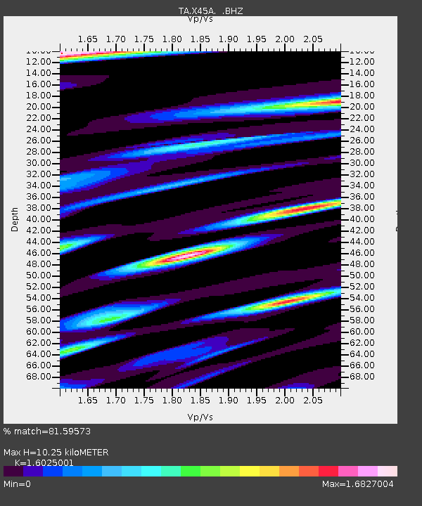
| Estimated Moho Depth: |
10.25 km |
| Estimated Crust Vp/Vs: |
1.60 |
| Assumed Crust Vp: |
6.38 km/s |
| Estimated Crust Vs: |
3.982 km/s |
| Estimated Crust Poisson's Ratio: |
0.18 |
|
| Radial Match: |
81.59573 % |
| Radial Bump: |
387 |
| Transverse Match: |
72.78462 % |
| Transverse Bump: |
391 |
| SOD ConfigId: |
424168 |
| Insert Time: |
2012-02-04 06:10:43.339 +0000 |
| GWidth: |
2.5 |
| Max Bumps: |
400 |
| Tol: |
0.001 |
|
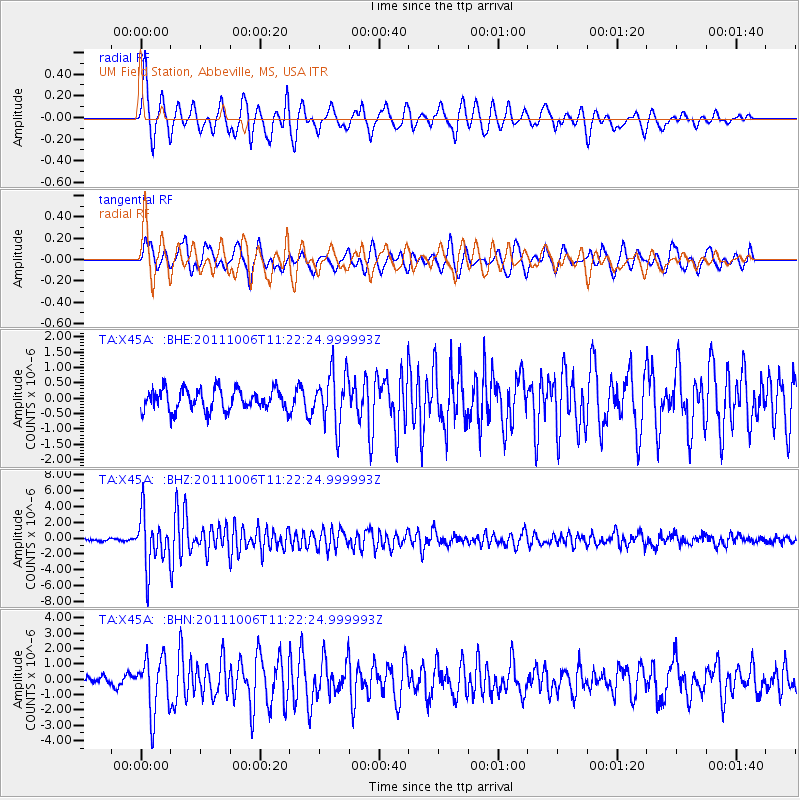
Signal To Noise
| Channel | StoN | STA | LTA |
| TA:X45A: :BHZ:20111006T11:22:24.999993Z | 20.033968 | 3.2480825E-6 | 1.6212877E-7 |
| TA:X45A: :BHN:20111006T11:22:24.999993Z | 3.5695689 | 1.8137408E-6 | 5.08112E-7 |
| TA:X45A: :BHE:20111006T11:22:24.999993Z | 2.475998 | 8.652245E-7 | 3.4944475E-7 |
| Arrivals |
| Ps | 1.0 SECOND |
| PpPs | 4.0 SECOND |
| PsPs/PpSs | 5.0 SECOND |


