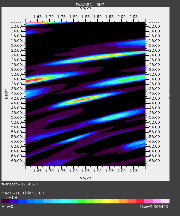
W45A Hickory Valley, TN, USA - Earthquake Result Viewer

Earthquake location: Salta Province, Argentina
Earthquake latitude/longitude: -24.2/-64.2
Earthquake time(UTC): 2011/10/06 (279) 11:12:30 GMT
Earthquake Depth: 15 km
Earthquake Magnitude: 6.5 MB, 5.7 MS, 6.1 MW, 5.9 MW
Earthquake Catalog/Contributor: WHDF/NEIC
Network: TA USArray Transportable Network (new EarthScope stations)
Station: W45A Hickory Valley, TN, USA
Lat/Lon: 35.16 N/89.19 W
Elevation: 187 m
Distance: 63.6 deg
Az: 337.282 deg
Baz: 154.503 deg
Ray Param: 0.05947442
Estimated Moho Depth: 10.0 km
Estimated Crust Vp/Vs: 1.60
Assumed Crust Vp: 6.38 km/s
Estimated Crust Vs: 3.988 km/s
Estimated Crust Poisson's Ratio: 0.18
Radial Match: 82.66536 %
Radial Bump: 400
Transverse Match: 76.15985 %
Transverse Bump: 400
SOD ConfigId: 424168
Insert Time: 2012-02-04 06:10:49.682 +0000
GWidth: 2.5
Max Bumps: 400
Tol: 0.001

Signal To Noise

ChannelStoNSTALTA
TA:W45A: :BHZ:20111006T11:22:28.874993Z20.2637183.4926156E-61.7235809E-7
TA:W45A: :BHN:20111006T11:22:28.874993Z6.227012.430088E-63.902496E-7
TA:W45A: :BHE:20111006T11:22:28.874993Z5.2909621.5670379E-62.9617257E-7
Arrivals
Ps1.0 SECOND
PpPs3.9 SECOND
PsPs/PpSs4.9 SECOND