You are here: Home > Network List > TA - USArray Transportable Network (new EarthScope stations) Stations List
> Station X43A Marvell, AR, USA > Earthquake Result Viewer
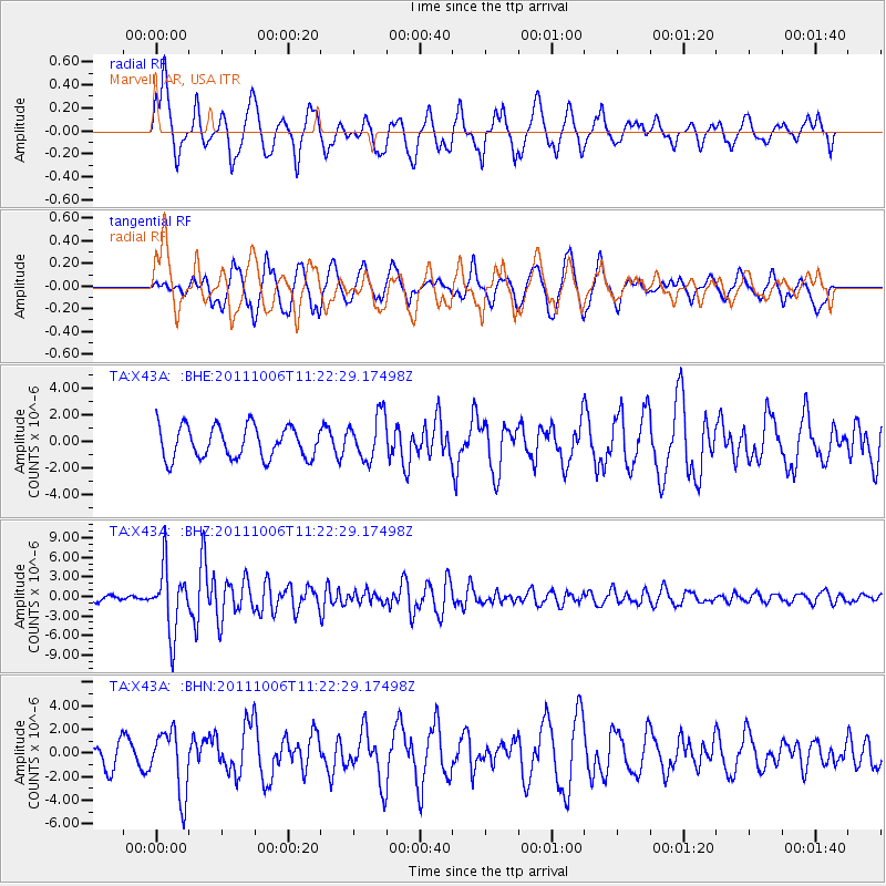
X43A Marvell, AR, USA - Earthquake Result Viewer
*The percent match for this event was below the threshold and hence no stack was calculated.
| Earthquake location: |
Salta Province, Argentina |
| Earthquake latitude/longitude: |
-24.2/-64.2 |
| Earthquake time(UTC): |
2011/10/06 (279) 11:12:30 GMT |
| Earthquake Depth: |
15 km |
| Earthquake Magnitude: |
6.5 MB, 5.7 MS, 6.1 MW, 5.9 MW |
| Earthquake Catalog/Contributor: |
WHDF/NEIC |
|
| Network: |
TA USArray Transportable Network (new EarthScope stations) |
| Station: |
X43A Marvell, AR, USA |
| Lat/Lon: |
34.52 N/90.88 W |
| Elevation: |
53 m |
|
| Distance: |
63.6 deg |
| Az: |
335.571 deg |
| Baz: |
152.779 deg |
| Ray Param: |
$rayparam |
*The percent match for this event was below the threshold and hence was not used in the summary stack. |
|
| Radial Match: |
75.35673 % |
| Radial Bump: |
400 |
| Transverse Match: |
61.73568 % |
| Transverse Bump: |
400 |
| SOD ConfigId: |
424168 |
| Insert Time: |
2012-02-04 06:10:58.302 +0000 |
| GWidth: |
2.5 |
| Max Bumps: |
400 |
| Tol: |
0.001 |
|
Signal To Noise
| Channel | StoN | STA | LTA |
| TA:X43A: :BHZ:20111006T11:22:29.17498Z | 12.95601 | 4.9330633E-6 | 3.8075484E-7 |
| TA:X43A: :BHN:20111006T11:22:29.17498Z | 2.3105247 | 2.6826208E-6 | 1.161044E-6 |
| TA:X43A: :BHE:20111006T11:22:29.17498Z | 1.4225109 | 1.7041984E-6 | 1.1980213E-6 |
| Arrivals |
| Ps | |
| PpPs | |
| PsPs/PpSs | |


