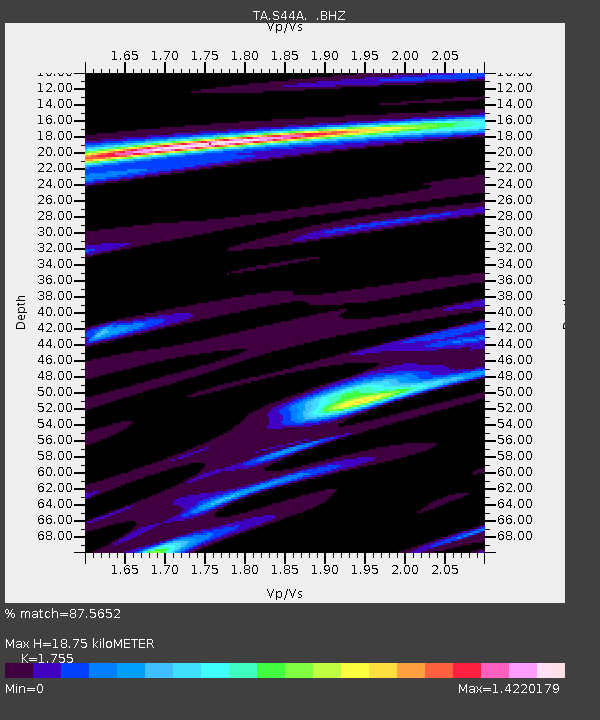
S44A Carbondale, IL, USA - Earthquake Result Viewer
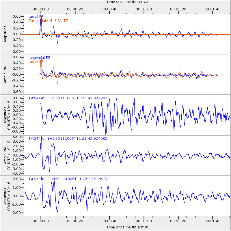
Earthquake location: Salta Province, Argentina
Earthquake latitude/longitude: -24.2/-64.2
Earthquake time(UTC): 2011/10/06 (279) 11:12:30 GMT
Earthquake Depth: 15 km
Earthquake Magnitude: 6.5 MB, 5.7 MS, 6.1 MW, 5.9 MW
Earthquake Catalog/Contributor: WHDF/NEIC
Network: TA USArray Transportable Network (new EarthScope stations)
Station: S44A Carbondale, IL, USA
Lat/Lon: 37.69 N/89.26 W
Elevation: 155 m
Distance: 65.9 deg
Az: 338.421 deg
Baz: 154.949 deg
Ray Param: 0.0579624
Estimated Moho Depth: 18.75 km
Estimated Crust Vp/Vs: 1.75
Assumed Crust Vp: 6.444 km/s
Estimated Crust Vs: 3.672 km/s
Estimated Crust Poisson's Ratio: 0.26
Radial Match: 87.5652 %
Radial Bump: 400
Transverse Match: 71.44297 %
Transverse Bump: 400
SOD ConfigId: 424168
Insert Time: 2012-02-04 06:11:20.218 +0000
GWidth: 2.5
Max Bumps: 400
Tol: 0.001

Signal To Noise

ChannelStoNSTALTA
TA:S44A: :BHZ:20111006T11:22:43.92498Z5.74078041.8948132E-63.3006194E-7
TA:S44A: :BHN:20111006T11:22:43.92498Z4.6261631.0562544E-62.2832194E-7
TA:S44A: :BHE:20111006T11:22:43.92498Z2.17295813.893495E-71.7917948E-7
Arrivals
Ps2.3 SECOND
PpPs7.7 SECOND
PsPs/PpSs10.0 SECOND