You are here: Home > Network List > TA - USArray Transportable Network (new EarthScope stations) Stations List
> Station Q43A New Douglas, IL, USA > Earthquake Result Viewer
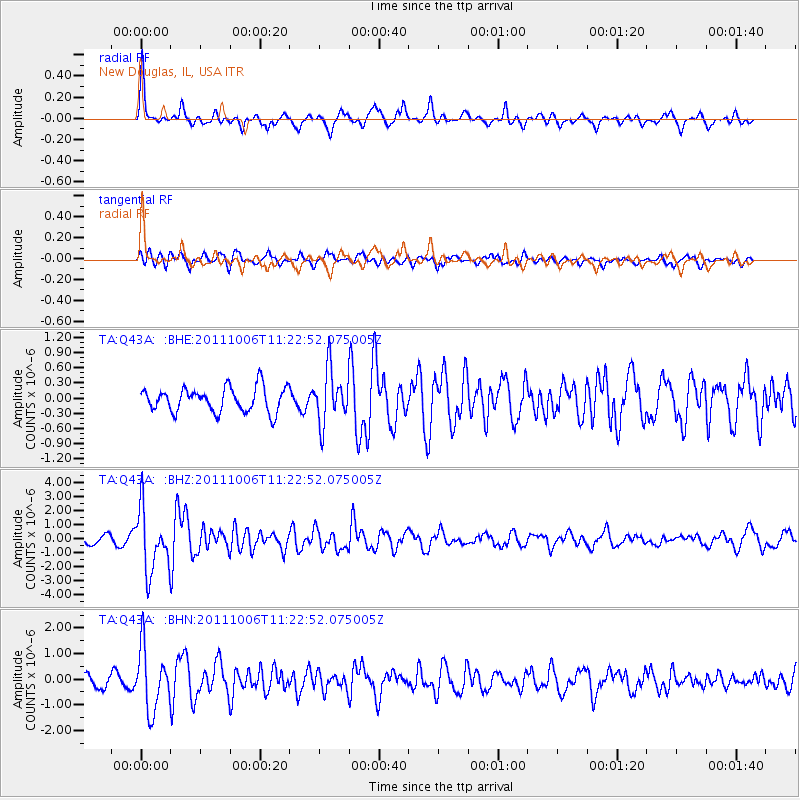
Q43A New Douglas, IL, USA - Earthquake Result Viewer
*The percent match for this event was below the threshold and hence no stack was calculated.
| Earthquake location: |
Salta Province, Argentina |
| Earthquake latitude/longitude: |
-24.2/-64.2 |
| Earthquake time(UTC): |
2011/10/06 (279) 11:12:30 GMT |
| Earthquake Depth: |
15 km |
| Earthquake Magnitude: |
6.5 MB, 5.7 MS, 6.1 MW, 5.9 MW |
| Earthquake Catalog/Contributor: |
WHDF/NEIC |
|
| Network: |
TA USArray Transportable Network (new EarthScope stations) |
| Station: |
Q43A New Douglas, IL, USA |
| Lat/Lon: |
38.94 N/89.70 W |
| Elevation: |
202 m |
|
| Distance: |
67.2 deg |
| Az: |
338.653 deg |
| Baz: |
154.767 deg |
| Ray Param: |
$rayparam |
*The percent match for this event was below the threshold and hence was not used in the summary stack. |
|
| Radial Match: |
76.662704 % |
| Radial Bump: |
338 |
| Transverse Match: |
72.51249 % |
| Transverse Bump: |
400 |
| SOD ConfigId: |
424168 |
| Insert Time: |
2012-02-04 06:11:34.450 +0000 |
| GWidth: |
2.5 |
| Max Bumps: |
400 |
| Tol: |
0.001 |
|
Signal To Noise
| Channel | StoN | STA | LTA |
| TA:Q43A: :BHZ:20111006T11:22:52.075005Z | 6.985769 | 2.2085685E-6 | 3.1615252E-7 |
| TA:Q43A: :BHN:20111006T11:22:52.075005Z | 5.794624 | 1.2101342E-6 | 2.0883742E-7 |
| TA:Q43A: :BHE:20111006T11:22:52.075005Z | 2.175949 | 5.246144E-7 | 2.410968E-7 |
| Arrivals |
| Ps | |
| PpPs | |
| PsPs/PpSs | |


