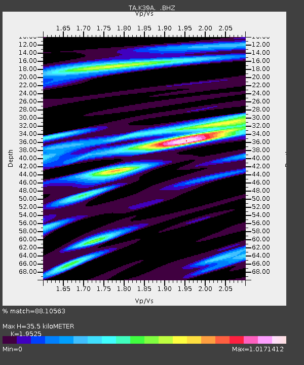
K39A Oelwein, IA, USA - Earthquake Result Viewer
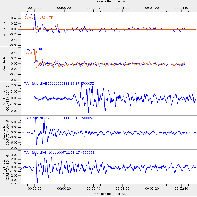
Earthquake location: Salta Province, Argentina
Earthquake latitude/longitude: -24.2/-64.2
Earthquake time(UTC): 2011/10/06 (279) 11:12:30 GMT
Earthquake Depth: 15 km
Earthquake Magnitude: 6.5 MB, 5.7 MS, 6.1 MW, 5.9 MW
Earthquake Catalog/Contributor: WHDF/NEIC
Network: TA USArray Transportable Network (new EarthScope stations)
Station: K39A Oelwein, IA, USA
Lat/Lon: 42.71 N/91.89 W
Elevation: 332 m
Distance: 71.3 deg
Az: 338.813 deg
Baz: 153.398 deg
Ray Param: 0.054426167
Estimated Moho Depth: 35.5 km
Estimated Crust Vp/Vs: 1.95
Assumed Crust Vp: 6.53 km/s
Estimated Crust Vs: 3.345 km/s
Estimated Crust Poisson's Ratio: 0.32
Radial Match: 88.10563 %
Radial Bump: 341
Transverse Match: 81.19073 %
Transverse Bump: 400
SOD ConfigId: 424168
Insert Time: 2012-02-04 06:12:05.759 +0000
GWidth: 2.5
Max Bumps: 400
Tol: 0.001

Signal To Noise

ChannelStoNSTALTA
TA:K39A: :BHZ:20111006T11:23:17.450005Z14.6237433.439336E-62.3518851E-7
TA:K39A: :BHN:20111006T11:23:17.450005Z7.59183261.6546119E-62.179463E-7
TA:K39A: :BHE:20111006T11:23:17.450005Z7.36061431.0212284E-61.3874228E-7
Arrivals
Ps5.4 SECOND
PpPs16 SECOND
PsPs/PpSs21 SECOND