You are here: Home > Network List > PY - PFO Array Stations List
> Station BPH03 Pinon Flat Observatory, CA, USA > Earthquake Result Viewer
BPH03 Pinon Flat Observatory, CA, USA - Earthquake Result Viewer
| Earthquake location: |
Solomon Islands |
| Earthquake latitude/longitude: |
-11.3/162.2 |
| Earthquake time(UTC): |
2014/04/12 (102) 20:14:39 GMT |
| Earthquake Depth: |
29 km |
| Earthquake Magnitude: |
7.6 MWW, 8.3 MI |
| Earthquake Catalog/Contributor: |
NEIC PDE/NEIC COMCAT |
|
| Network: |
PY PFO Array |
| Station: |
BPH03 Pinon Flat Observatory, CA, USA |
| Lat/Lon: |
33.61 N/116.46 W |
| Elevation: |
1285 m |
|
| Distance: |
89.1 deg |
| Az: |
55.599 deg |
| Baz: |
255.869 deg |
| Ray Param: |
0.042072136 |
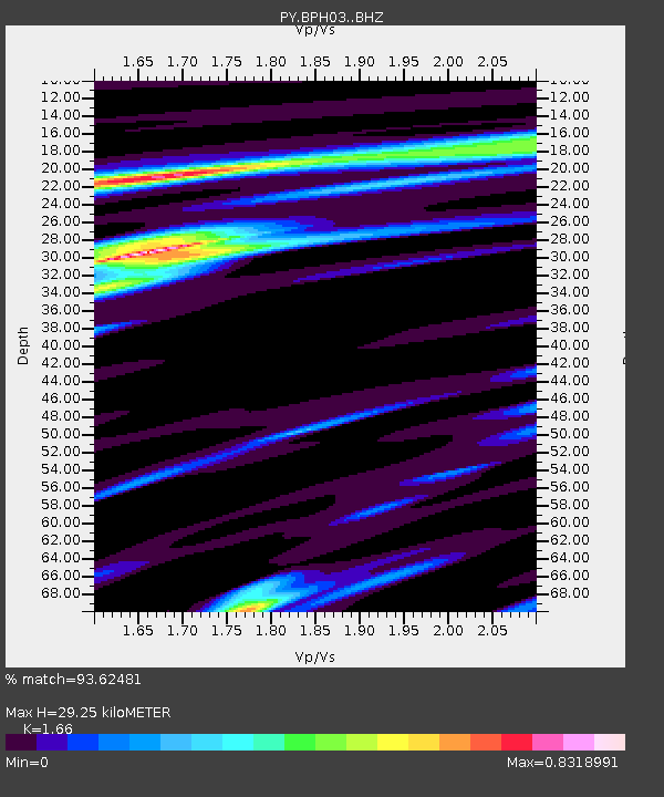
| Estimated Moho Depth: |
29.25 km |
| Estimated Crust Vp/Vs: |
1.66 |
| Assumed Crust Vp: |
6.264 km/s |
| Estimated Crust Vs: |
3.773 km/s |
| Estimated Crust Poisson's Ratio: |
0.22 |
|
| Radial Match: |
93.62481 % |
| Radial Bump: |
313 |
| Transverse Match: |
85.83869 % |
| Transverse Bump: |
400 |
| SOD ConfigId: |
3390531 |
| Insert Time: |
2019-04-11 08:07:18.866 +0000 |
| GWidth: |
2.5 |
| Max Bumps: |
400 |
| Tol: |
0.001 |
|

Signal To Noise
| Channel | StoN | STA | LTA |
| PY:BPH03: :BHZ:20140412T20:27:01.59998Z | 5.1548476 | 1.1048475E-6 | 2.1433175E-7 |
| PY:BPH03: :BHN:20140412T20:27:01.59998Z | 0.6440525 | 9.65584E-8 | 1.4992318E-7 |
| PY:BPH03: :BHE:20140412T20:27:01.59998Z | 3.3886287 | 3.7429433E-7 | 1.1045599E-7 |
| Arrivals |
| Ps | 3.1 SECOND |
| PpPs | 12 SECOND |
| PsPs/PpSs | 15 SECOND |


