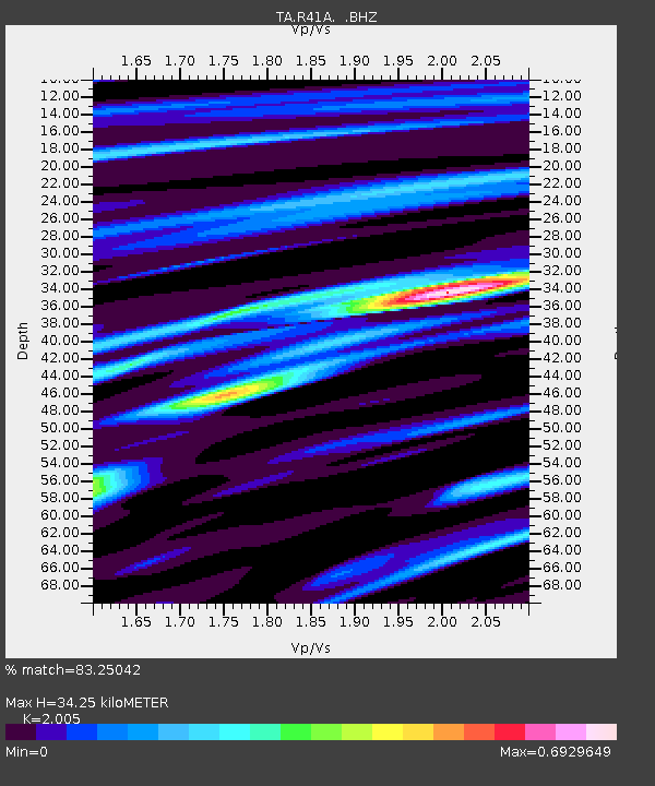
R41A Rosebud, MO, USA - Earthquake Result Viewer

Earthquake location: Salta Province, Argentina
Earthquake latitude/longitude: -24.2/-64.2
Earthquake time(UTC): 2011/10/06 (279) 11:12:30 GMT
Earthquake Depth: 15 km
Earthquake Magnitude: 6.5 MB, 5.7 MS, 6.1 MW, 5.9 MW
Earthquake Catalog/Contributor: WHDF/NEIC
Network: TA USArray Transportable Network (new EarthScope stations)
Station: R41A Rosebud, MO, USA
Lat/Lon: 38.30 N/91.38 W
Elevation: 257 m
Distance: 67.2 deg
Az: 337.064 deg
Baz: 153.106 deg
Ray Param: 0.05712064
Estimated Moho Depth: 34.25 km
Estimated Crust Vp/Vs: 2.01
Assumed Crust Vp: 6.498 km/s
Estimated Crust Vs: 3.241 km/s
Estimated Crust Poisson's Ratio: 0.33
Radial Match: 83.25042 %
Radial Bump: 346
Transverse Match: 64.451454 %
Transverse Bump: 334
SOD ConfigId: 424168
Insert Time: 2012-02-04 06:13:59.283 +0000
GWidth: 2.5
Max Bumps: 400
Tol: 0.001

Signal To Noise

ChannelStoNSTALTA
TA:R41A: :BHZ:20111006T11:22:52.075005Z12.8291192.6758776E-62.0857844E-7
TA:R41A: :BHN:20111006T11:22:52.075005Z3.49020931.0170268E-62.9139423E-7
TA:R41A: :BHE:20111006T11:22:52.075005Z2.50509866.2889114E-72.5104447E-7
Arrivals
Ps5.5 SECOND
PpPs15 SECOND
PsPs/PpSs21 SECOND